|
search place name
|
||
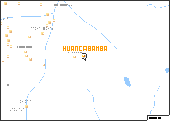
Huancabamba (Pasco, Peru)Huancabamba is a town in the Pasco region of Peru. An overview map of the region around Huancabamba is displayed below.
regional and 3d topo map of Huancabamba, Peru ::
Huancabamba airports ::
The nearest airport is LIM - Lima Jorge Chavez Intl, located 206.4 km south west of Huancabamba.
Other airports nearby include ATA - Anta Comandante Fap German Arias Graziani (213.2 km north west), Nearby towns ::
Jagraran (2.3km west) //
Gocampampa (8.6km north west) //
Cogancocha (11.1km north west) //
Ocllac (11.1km north west) //
Chalhuacocha (11.4km north west) //
Piana (11.5km north west) //
[all distances 'as the bird flies' and approximate]  Places with similar names to Huancabamba, Peru ::
// Huancabamba (PE)
// Huancabamba (PE)
// Huancabamba (PE)
// Huancabamba (PE)
// Huancabamba (PE)
// Hàng Bom (VN)
Disclaimer :: Information on this page comes without warranty of any kind |
||
|
Where is Huancabamba? Elevation and coordinates ::
Latitude (lat): 10°29'28"S Longitude (lon): 76°2'2"W
Elevation (approx.): 4180m (map arrows pan, magnifying glasses zoom) |
||
|
Visiting Huancabamba? Hotel/Accommodation ::
Book a hotel in Huancabamba Travel Guide ::
Buy a travel guide for Peru rental cars ::
car rental offers GPS waypoint ::
download a GPX waypoint (PoI) of Huancabamba for your GPS receiver
|
||