|
search place name
|
||
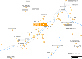
Huishcol (Lima, Peru)Huishcol is a town in the Lima region of Peru. An overview map of the region around Huishcol is displayed below.
regional and 3d topo map of Huishcol, Peru ::
Huishcol airports ::
The nearest airport is LIM - Lima Jorge Chavez Intl, located 83.9 km west of Huishcol.
Other airports nearby include PIO - Pisco Intl (213.3 km south), Nearby towns ::
San Juan de Allauca (1.1km west) //
Cacachaqui (1.2km south) //
Huangro (1.3km south east) //
Timapampa (1.4km south west) //
Umazamba (1.5km east) //
Chuelocuya (2.2km south) //
Marachanca (2.2km south east) //
Paihua (2.2km west) //
Chilca (2.4km south) //
Puquiña (2.4km south) //
Untorios (2.5km north east) //
Anay (2.6km south) //
Huaripampa (2.8km south west) //
Tunacocha (3.0km east) //
Viste Alegre (3.1km north east) //
Orocococha (3.2km south) //
Escompilla (3.3km north) //
Malla (3.4km north west) //
Sacalla (3.5km south) //
Tambo de Viso (3.6km north east) //
Mocho (3.7km north) //
Pucara (3.8km south) //
Los Olivos (3.8km south west) //
Untun (3.8km south) //
Quicha (4.1km north) //
Soca (4.1km south) //
Metala (4.2km south) //
Buena Vista (4.3km south) //
Matucana (4.3km south west) //
[all distances 'as the bird flies' and approximate]  Places with similar names to Huishcol, Peru ::
// Hichocollo (PE)
// Hichocollo (PE)
// Hichocollo (PE)
// Hichocollo (PE)
// Hŏch'a-gol (KP)
// Huachacalla (BO)
// Huchucollo (BO)
Disclaimer :: Information on this page comes without warranty of any kind |
||
|
Where is Huishcol? Elevation and coordinates ::
Latitude (lat): 11°49'21"S Longitude (lon): 76°22'18"W
Elevation (approx.): 2773m (map arrows pan, magnifying glasses zoom) |
||
|
Visiting Huishcol? Hotel/Accommodation ::
Book a hotel in Huishcol Travel Guide ::
Buy a travel guide for Peru rental cars ::
car rental offers GPS waypoint ::
download a GPX waypoint (PoI) of Huishcol for your GPS receiver
|
||