|
search place name
|
||
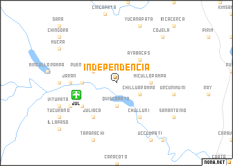
Independencia (Puno, Peru)Independencia is a town in the Puno region of Peru. An overview map of the region around Independencia is displayed below.
regional and 3d topo map of Independencia, Peru ::
Independencia airports ::
The nearest airport is JUL - Juliaca, located 6.5 km west of Independencia.
Other airports nearby include AQP - Arequipa Rodriguez Ballon (186.9 km south west), LPB - La Paz El Alto Intl (235.7 km south east), CUZ - Cuzco Teniente Alejandro Velasco Astete Intl (290.1 km north west), Nearby towns ::
Quiscapata (3.7km south) //
Chilluapampa (4.0km south east) //
Puente Maravillas (4.0km north west) //
Ayabacas (5.1km north east) //
Micullopampa (5.4km east) //
Balsapata (5.4km west) //
Chulluni (6.6km south east) //
Juliaca (6.6km south west) //
Urubambilla (6.5km south west) //
Jarán (7.1km west) //
Caracanto (8.0km south west) //
Cojela (10.3km north east) //
[all distances 'as the bird flies' and approximate] 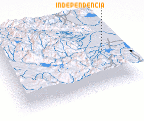 Places with similar names to Independencia, Peru ::
// Independencia (CU)
// Independencia (CO)
// Independencia (CO)
// Independencia (CO)
// Independencia (EC)
// Independencia (EC)
// Independencia (EC)
// Independencia (MX)
// Independencia (MX)
// Independencia (MX)
Disclaimer :: Information on this page comes without warranty of any kind |
||
|
Where is Independencia? Elevation and coordinates ::
Latitude (lat): 15°27'0"S Longitude (lon): 70°6'0"W
Elevation (approx.): 3830m (map arrows pan, magnifying glasses zoom) |
||
|
Visiting Independencia? Hotel/Accommodation ::
Book a hotel in Independencia Travel Guide ::
Buy a travel guide for Peru rental cars ::
car rental offers GPS waypoint ::
download a GPX waypoint (PoI) of Independencia for your GPS receiver
|
||