|
search place name
|
||
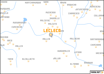
Lecleca (Arequipa, Peru)Lecleca is a town in the Arequipa region of Peru. An overview map of the region around Lecleca is displayed below.
regional and 3d topo map of Lecleca, Peru ::
Lecleca airports ::
The nearest airport is AQP - Arequipa Rodriguez Ballon, located 140.6 km south east of Lecleca.
Other airports nearby include ANS - Andahuaylas (210.5 km north west), CUZ - Cuzco Teniente Alejandro Velasco Astete Intl (214.9 km north), Nearby towns ::
Pallca (2.5km south west) //
Ocoruro (3.0km north east) //
Callalli (3.5km north) //
Palcuyo (3.8km north) //
Achaco (4.1km north east) //
Huyshuta (5.0km east) //
Palcoyoc (5.6km north west) //
Shupalle (6.0km north) //
Huagapalca (7.2km south east) //
Auchaca (7.6km north) //
Pucacasa (7.9km north) //
Palcacha (8.1km east) //
Huamantirca (8.6km south east) //
Jallua (8.9km south) //
Chapacoco (10.8km north east) //
Alco-Llacta (12.0km south west) //
[all distances 'as the bird flies' and approximate] 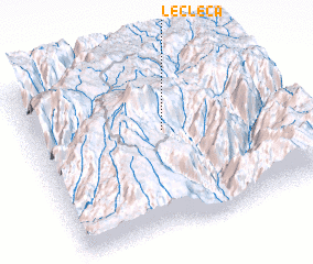 Places with similar names to Lecleca, Peru ::
Disclaimer :: Information on this page comes without warranty of any kind |
||
|
Where is Lecleca? Elevation and coordinates ::
Latitude (lat): 15°24'24"S Longitude (lon): 72°28'24"W
Elevation (approx.): 4193m (map arrows pan, magnifying glasses zoom) |
||
|
Visiting Lecleca? Hotel/Accommodation ::
Book a hotel in Lecleca Travel Guide ::
Buy a travel guide for Peru rental cars ::
car rental offers GPS waypoint ::
download a GPX waypoint (PoI) of Lecleca for your GPS receiver
|
||