|
search place name
|
||
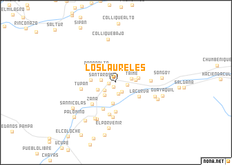
Los Laureles (Lambayeque, Peru)Los Laureles is a town in the Lambayeque region of Peru. An overview map of the region around Los Laureles is displayed below.
regional and 3d topo map of Los Laureles, Peru ::
Los Laureles airports ::
The nearest airport is CIX - Chiclayo Capt Jose A Quinones Gonzales Intl, located 32.8 km west of Los Laureles.
Other airports nearby include TRU - Trujillo Capitan Carlos Martinez De Pinillos (140.4 km south), CHH - Chachapoyas (202.2 km east), PIU - Piura Capitan Fap Guillermo Concha Iberico (220.6 km north west), Nearby towns ::
Alto Perú (0.8km south west) //
Cerro León (1.1km north) //
Cayaltí (1.2km west) //
Aviación (1.8km south east) //
Corral de Palo (1.8km east) //
Santa Sofia (1.9km south) //
Nuevo Mexico (2.2km south west) //
Santa Rosa (2.5km west) //
Taime (2.6km east) //
Chacarilla (2.8km south west) //
Las Adelinas (3.2km west) //
Cafetal (3.2km east) //
San Baldomero (3.4km south) //
Cojal (3.7km east) //
Popan Alto (3.9km north west) //
Popan Bajo (4.1km west) //
La Curva (4.4km south east) //
Salitral (4.7km south west) //
Mata Indio (4.8km south) //
Zaña (5.2km south west) //
El Potrero (5.3km south) //
Hacienda Cojal (5.6km east) //
Tres Compuertas (5.7km south) //
Tupan (5.7km west) //
Huaca Tendida (6.6km east) //
La Otra Banda (6.7km south west) //
Otra Banda (6.7km south west) //
Collique Bajo (7.1km north) //
Huaca La Ternera (7.3km east) //
[all distances 'as the bird flies' and approximate] 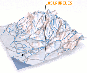 Places with similar names to Los Laureles, Peru ::
// Los Laureles (CU)
// Los Laureles (CL)
// Los Laureles (CL)
// Los Laureles (CL)
// Los Laureles (CO)
// Los Laureles (CO)
// Los Laureles (CO)
// Los Laureles (CO)
// Los Laureles (CO)
// Los Laureles (CO)
Disclaimer :: Information on this page comes without warranty of any kind |
||
|
Where is Los Laureles? Elevation and coordinates ::
Latitude (lat): 6°53'25"S Longitude (lon): 79°32'59"W
Elevation (approx.): 80m (map arrows pan, magnifying glasses zoom) |
||
|
Visiting Los Laureles? Hotel/Accommodation ::
Book a hotel in Los Laureles Travel Guide ::
Buy a travel guide for Peru rental cars ::
car rental offers GPS waypoint ::
download a GPX waypoint (PoI) of Los Laureles for your GPS receiver
|
||