|
search place name
|
||
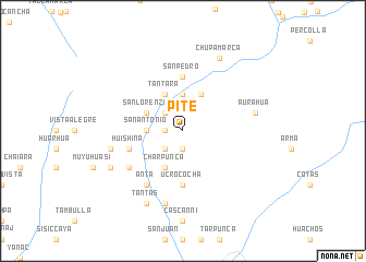
Pite (Huancavelica, Peru)Pite is a town in the Huancavelica region of Peru. An overview map of the region around Pite is displayed below.
regional and 3d topo map of Pite, Peru ::
Pite airports ::
The nearest airport is PIO - Pisco Intl, located 95.6 km south west of Pite.
Other airports nearby include AYP - Ayacucho Coronel Fap Alfredo Mendivil Duarte (155.1 km east), LIM - Lima Jorge Chavez Intl (200.3 km north west), Nearby towns ::
Buenos Aires (1.9km south) //
Llancas (1.8km west) //
Allcas (1.8km west) //
Pumas (1.8km west) //
El Prado (2.6km south west) //
Santa Rosa (2.6km south west) //
Pucapaccha (2.6km north west) //
Cauras (3.7km north) //
Huantay (3.6km west) //
Ataumarca (3.6km west) //
San Antonio (3.6km west) //
Ccenccella (4.1km north east) //
Tantara (4.1km north west) //
Charpunca (4.1km south west) //
San Lorenzo (4.1km north west) //
San Pedro (5.6km north) //
Ucrococha (5.6km south) //
Comunpata (5.7km west) //
Huishina (5.7km west) //
Huamatambo (5.7km west) //
Huancaya (6.6km south west) //
Anta (6.6km south west) //
Aurahuá (7.5km east) //
Huayllapua (7.5km west) //
Amailla (7.6km south) //
Ccoña (8.1km south west) //
Chupamarca (8.2km north east) //
Tantas (8.2km south west) //
[all distances 'as the bird flies' and approximate] 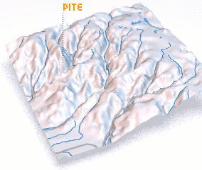 Places with similar names to Pite, Peru ::
Disclaimer :: Information on this page comes without warranty of any kind |
||
|
Where is Pite? Elevation and coordinates ::
Latitude (lat): 13°6'0"S Longitude (lon): 75°38'0"W
Elevation (approx.): 3872m (map arrows pan, magnifying glasses zoom) |
||
|
Visiting Pite? Hotel/Accommodation ::
Book a hotel in Pite Travel Guide ::
Buy a travel guide for Peru rental cars ::
car rental offers GPS waypoint ::
download a GPX waypoint (PoI) of Pite for your GPS receiver
|
||