|
search place name
|
||
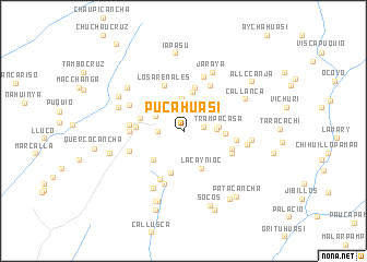
Pucahuasi (Huancavelica, Peru)Pucahuasi is a town in the Huancavelica region of Peru. An overview map of the region around Pucahuasi is displayed below.
regional and 3d topo map of Pucahuasi, Peru ::
Pucahuasi airports ::
The nearest airport is PIO - Pisco Intl, located 119.7 km west of Pucahuasi.
Other airports nearby include AYP - Ayacucho Coronel Fap Alfredo Mendivil Duarte (143.5 km north east), ANS - Andahuaylas (199.3 km east), Nearby towns ::
Pampajocha (2.0km east) //
Lindero (2.5km west) //
Lagualla (3.0km north east) //
Chuspe (3.2km north) //
Córdova (3.2km north west) //
Uchpa (3.2km east) //
Lejlejo (3.5km north west) //
Trampacasa (3.5km east) //
Lanlanlla (4.0km north) //
San Andrés de Quilcanto (4.1km south west) //
Lacaynioc (4.2km south east) //
Rayan (4.1km east) //
Huambo (4.3km north west) //
Tibillo (4.5km south) //
Imillay (4.5km north east) //
Huaranga (4.6km north) //
Ticcra (4.5km west) //
Contejasa (4.8km west) //
Los Arenales (5.1km north west) //
Palca (5.0km east) //
Huachojayco (5.3km north east) //
Conte Conte (5.3km south east) //
Cochanca Chico (5.3km west) //
Chochoca (5.5km south west) //
Paclapata (5.4km west) //
Las Mercedes (5.4km east) //
Apoca (5.8km north) //
Uchuachi (5.8km south) //
Patahuasi (5.7km west) //
[all distances 'as the bird flies' and approximate]  Places with similar names to Pucahuasi, Peru ::
Disclaimer :: Information on this page comes without warranty of any kind |
||
|
Where is Pucahuasi? Elevation and coordinates ::
Latitude (lat): 14°3'16"S Longitude (lon): 75°9'34"W
Elevation (approx.): 2591m (map arrows pan, magnifying glasses zoom) |
||
|
Visiting Pucahuasi? Hotel/Accommodation ::
Book a hotel in Pucahuasi Travel Guide ::
Buy a travel guide for Peru rental cars ::
car rental offers GPS waypoint ::
download a GPX waypoint (PoI) of Pucahuasi for your GPS receiver
|
||