|
search place name
|
||
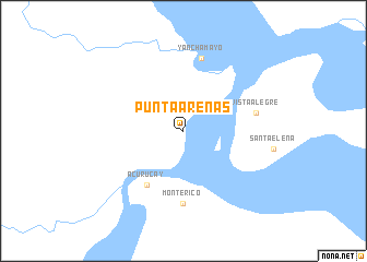
Punta Arenas (Loreto, Peru)Punta Arenas is a town in the Loreto region of Peru. An overview map of the region around Punta Arenas is displayed below.
regional and 3d topo map of Punta Arenas, Peru ::
Punta Arenas airports ::
The nearest airport is YMS - Yurimaguas Moises Benzaquen Rengifo, located 131.5 km south west of Punta Arenas.
Other airports nearby include TPP - Tarapoto Cadete Guillermo Del Castillo Paredes (204.3 km south west), Nearby towns ::
Acurucay (6.7km south west) //
Monte Rico (7.4km south) //
Vista Alegre (7.6km east) //
Yanchamayo (7.6km north) //
[all distances 'as the bird flies' and approximate] 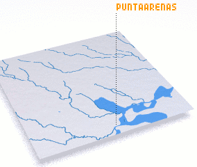 Places with similar names to Punta Arenas, Peru ::
// Pino Troinese (IT)
// Puente-Arenas (ES)
// Punta Arenas (CL)
// Puntarenas (CR)
// Puntarenas (GT)
// Punta Arenas (VE)
Disclaimer :: Information on this page comes without warranty of any kind |
||
|
Where is Punta Arenas? Elevation and coordinates ::
Latitude (lat): 4°54'0"S Longitude (lon): 75°28'0"W
Elevation (approx.): 126m (map arrows pan, magnifying glasses zoom) |
||
|
Visiting Punta Arenas? Hotel/Accommodation ::
Book a hotel in Punta Arenas Travel Guide ::
Buy a travel guide for Peru rental cars ::
car rental offers GPS waypoint ::
download a GPX waypoint (PoI) of Punta Arenas for your GPS receiver
|
||