|
search place name
|
||
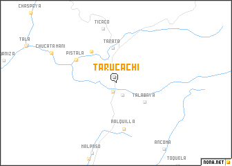
Tarucachi (Tacna, Peru)Tarucachi is a town in the Tacna region of Peru. An overview map of the region around Tarucachi is displayed below.
regional and 3d topo map of Tarucachi, Peru ::
Tarucachi airports ::
The nearest airport is TCQ - Tacna Coronel Carlos Ciriani Santa Rosa Intl, located 64.1 km south west of Tarucachi.
Other airports nearby include ARI - Arica Chacalluta (96.9 km south), AQP - Arequipa Rodriguez Ballon (211.2 km north west), LPB - La Paz El Alto Intl (225.3 km north east), Nearby towns ::
Estique Pampa (1.5km south) //
Estique (2.2km south east) //
Talabaya (5.4km south east) //
Tarata (5.6km north) //
Churopampa (6.3km north west) //
Pistala (7.2km north west) //
Palquilla (7.5km south) //
Ticaco (8.9km north) //
[all distances 'as the bird flies' and approximate] 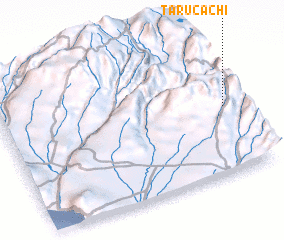 Places with similar names to Tarucachi, Peru ::
// Tarakuishi (RU)
// Torcochi (BO)
// Torgashi (RU)
// Turgosh' (RU)
// Turgosh' (RU)
// Turkash (RU)
// Turkushi (RU)
// Tragasiá (GR)
// Dargaičiai (LT)
// Dargaičiai I (LT)
Disclaimer :: Information on this page comes without warranty of any kind |
||
|
Where is Tarucachi? Elevation and coordinates ::
Latitude (lat): 17°31'29"S Longitude (lon): 70°1'42"W
Elevation (approx.): 3112m (map arrows pan, magnifying glasses zoom) |
||
|
Visiting Tarucachi? Hotel/Accommodation ::
Book a hotel in Tarucachi Travel Guide ::
Buy a travel guide for Peru rental cars ::
car rental offers GPS waypoint ::
download a GPX waypoint (PoI) of Tarucachi for your GPS receiver
|
||