|
search place name
|
||
Uchuracra (Junín, Peru)Uchuracra is a town in the Junín region of Peru. An overview map of the region around Uchuracra is displayed below.
regional and 3d topo map of Uchuracra, Peru ::

Uchuracra airports ::
The nearest airport is LIM - Lima Jorge Chavez Intl, located 168.5 km south west of Uchuracra.
Other airports nearby include AYP - Ayacucho Coronel Fap Alfredo Mendivil Duarte (257.2 km south east), Nearby towns ::
Umanconcha (1.1km north east) //
Cuyrohuasi (1.8km west) //
Casampa (2.3km west) //
Hualloan (2.7km south west) //
Buenos Aires (2.9km north) //
Huacachacra (2.9km east) //
Jacahuasi (3.0km south east) //
Mayoc (3.2km south west) //
Tupin (3.6km east) //
Huchhuacocha (3.7km east) //
Shieshar (3.7km south east) //
Pomachaca (3.7km south east) //
Hualhuash (3.8km east) //
Ninatambo (3.8km south east) //
Esquecha (4.0km north west) //
Leticia (4.1km west) //
La Florida (4.4km east) //
Esquecha (4.8km north west) //
Pallca Urán (4.9km north) //
Hualhuash (4.9km south east) //
Hualhuash (5.2km south east) //
Sacsamarca (5.4km south) //
Chuchupampa (5.6km south) //
Ruraymarca (5.6km north east) //
Picoy (5.8km north east) //
Mullucro (5.8km south) //
Huinco (5.9km south) //
Vista Alegre (5.9km south east) //
Casablanca (6.0km south) //
[all distances 'as the bird flies' and approximate] 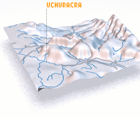 Places with similar names to Uchuracra, Peru :: Disclaimer :: Information on this page comes without warranty of any kind |
||
|
Where is Uchuracra? Elevation and coordinates ::
Latitude (lat): 11°22'6"S Longitude (lon): 75°43'4"W
Elevation (approx.): 3188m (map arrows pan, magnifying glasses zoom) |
||
|
Visiting Uchuracra? Hotel/Accommodation ::
Book a hotel in Uchuracra Travel Guide ::
Buy a travel guide for Peru rental cars ::
car rental offers GPS waypoint ::
download a GPX waypoint (PoI) of Uchuracra for your GPS receiver
|
||