|
search place name
|
||
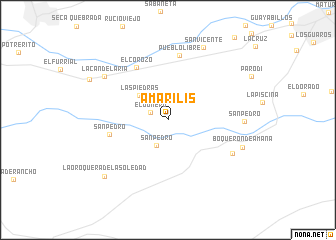
Amarilis (Monagas, Venezuela)Amarilis is a town in the Monagas region of Venezuela. An overview map of the region around Amarilis is displayed below.
regional and 3d topo map of Amarilis, Venezuela ::
Amarilis airports ::
The nearest airport is MUN - Maturin, located 23.4 km north east of Amarilis.
Other airports nearby include CUP - Carupano General Jose Francisco Bermudez (112.9 km north), SOM - San Tome (118.0 km south west), CUM - Cumana Antonio Jose De Sucre (124.6 km north west), AAO - Anaco (126.6 km west), Nearby towns ::
El Gomero (2.1km west) //
San Pedro (3.2km south west) //
Las Piedras (4.1km north west) //
San Pedro (6.7km west) //
El Corozo (6.8km north west) //
Pueblo Libre (7.3km north) //
Moreno (8.0km south east) //
San Pedro (8.4km east) //
La Candelaria (8.5km north west) //
Boquerón de Amana (8.8km east) //
San Vicente (9.0km north east) //
La Oroquera de La Soledad (9.4km south west) //
El Mapurito (9.7km north west) //
[all distances 'as the bird flies' and approximate]  Places with similar names to Amarilis, Venezuela ::
Disclaimer :: Information on this page comes without warranty of any kind |
||
|
Where is Amarilis? Elevation and coordinates ::
Latitude (lat): 9°38'33"N Longitude (lon): 63°20'17"W
Elevation (approx.): 96m (map arrows pan, magnifying glasses zoom) |
||
|
Visiting Amarilis? Hotel/Accommodation ::
Book a hotel in Amarilis Travel Guide ::
Buy a travel guide for Venezuela rental cars ::
car rental offers GPS waypoint ::
download a GPX waypoint (PoI) of Amarilis for your GPS receiver
|
||