|
search place name
|
||
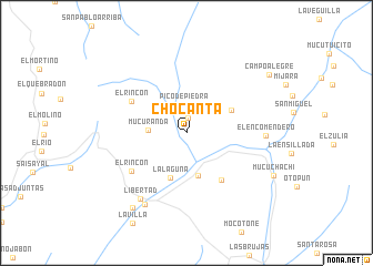
Chocantá (Mérida, Venezuela)Chocantá is a town in the Mérida region of Venezuela. An overview map of the region around Chocantá is displayed below.
regional and 3d topo map of Chocantá, Venezuela ::
Chocantá airports ::
The nearest airport is MRD - Merida Alberto Carnevalli, located 51.9 km north east of Chocantá.
Other airports nearby include LFR - La Fria (94.2 km west), STD - Santo Domingo Mayor Buenaventura Vivas (96.9 km south west), STB - Santa Barbara Del Zulia (104.5 km north west), SVZ - San Antonio Del Tachira (119.1 km west), Nearby towns ::
El Cotudo (1.5km north) //
Pico de Piedra (2.9km north) //
Mucurandá (3.8km west) //
El Bao (4.5km south) //
La Laguna (4.8km south) //
Agua Blanca (5.0km north east) //
El Carrizal (5.9km south east) //
El Rincón (6.3km north west) //
El Rincón (6.7km south west) //
El Encomendero (7.9km east) //
Libertad (8.0km south west) //
Los Naranjos (8.3km south west) //
Valle de La Cruz (9.3km south west) //
Mucuchachí (9.7km south east) //
Campo Alegre (10.1km north east) //
[all distances 'as the bird flies' and approximate] 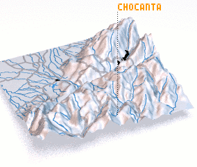 Places with similar names to Chocantá, Venezuela ::
Disclaimer :: Information on this page comes without warranty of any kind |
||
|
Where is Chocantá? Elevation and coordinates ::
Latitude (lat): 8°11'17"N Longitude (lon): 71°25'2"W
Elevation (approx.): 1483m (map arrows pan, magnifying glasses zoom) |
||
|
Visiting Chocantá? Hotel/Accommodation ::
Book a hotel in Chocantá Travel Guide ::
Buy a travel guide for Venezuela rental cars ::
car rental offers GPS waypoint ::
download a GPX waypoint (PoI) of Chocantá for your GPS receiver
|
||