|
search place name
|
||
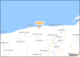
Dara (Falcón, Venezuela)Dara is a town in the Falcón region of Venezuela. An overview map of the region around Dara is displayed below.
regional and 3d topo map of Dara, Venezuela ::
Dara airports ::
The nearest airport is LSP - Paraguana Josefa Camejo, located 83.9 km north east of Dara.
Other airports nearby include CZE - Coro Jose Leonardo Chirinos (110.1 km east), MAR - Maracaibo La Chinita Intl (136.9 km south west), AUA - Oranjestad Reina Beatrix Intl (158.7 km north east), BRM - Barquisimeto Intl (193.9 km south east), Nearby towns ::
San Nicolás (3.9km south) //
El Suite (4.5km west) //
El Rincón (6.7km south) //
Los Ranchos (7.2km south east) //
Puerto Gutiérrez (7.4km east) //
Santa Clara (7.6km south west) //
Capatárida (7.9km south east) //
Jaramito (8.3km south east) //
Guayacán (9.1km south east) //
Quitare (9.7km south east) //
La Ciénaga (10.2km south east) //
[all distances 'as the bird flies' and approximate] 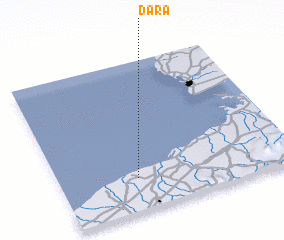 Places with similar names to Dara, Venezuela ::
Disclaimer :: Information on this page comes without warranty of any kind |
||
|
Where is Dara? Elevation and coordinates ::
Latitude (lat): 11°13'14"N Longitude (lon): 70°40'14"W
Elevation (approx.): 13m (map arrows pan, magnifying glasses zoom) |
||
|
Visiting Dara? Hotel/Accommodation ::
Book a hotel in Dara Travel Guide ::
Buy a travel guide for Venezuela rental cars ::
car rental offers GPS waypoint ::
download a GPX waypoint (PoI) of Dara for your GPS receiver
|
||