|
search place name
|
||
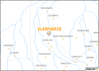
El Esfuerzo (Táchira, Venezuela)El Esfuerzo is a town in the Táchira region of Venezuela. An overview map of the region around El Esfuerzo is displayed below.
regional and 3d topo map of El Esfuerzo, Venezuela ::
El Esfuerzo airports ::
The nearest airport is LFR - La Fria, located 34.7 km south west of El Esfuerzo.
Other airports nearby include STB - Santa Barbara Del Zulia (55.0 km north), CUC - Cucuta Camilo Daza (78.1 km south west), SVZ - San Antonio Del Tachira (82.2 km south west), MRD - Merida Alberto Carnevalli (103.6 km east), Nearby towns ::
Los Olivos (2.9km south) //
Los Andes (4.3km south) //
Puente Tablas (5.2km south) //
Veintitres de Enero (5.3km east) //
Cucharón (6.6km north) //
Río Chiquito (8.4km south) //
[all distances 'as the bird flies' and approximate] 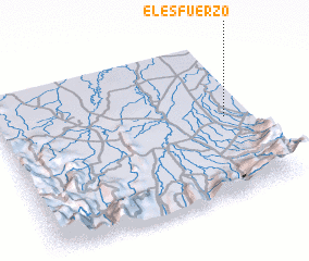 Places with similar names to El Esfuerzo, Venezuela ::
// El Esfuerzo (CO)
// El Esfuerzo (CO)
// El Esfuerzo (CO)
// El Esfuerzo (EC)
// El Esfuerzo (MX)
// El Esfuerzo (HN)
// El Esfuerzo (VE)
// El Esfuerzo (NI)
// El Esfuerzo (CO)
Disclaimer :: Information on this page comes without warranty of any kind |
||
|
Where is El Esfuerzo? Elevation and coordinates ::
Latitude (lat): 8°30'7"N Longitude (lon): 72°5'57"W
Elevation (approx.): 32m (map arrows pan, magnifying glasses zoom) |
||
|
Visiting El Esfuerzo? Hotel/Accommodation ::
Book a hotel in El Esfuerzo Travel Guide ::
Buy a travel guide for Venezuela rental cars ::
car rental offers GPS waypoint ::
download a GPX waypoint (PoI) of El Esfuerzo for your GPS receiver
|
||