|
search place name
|
||
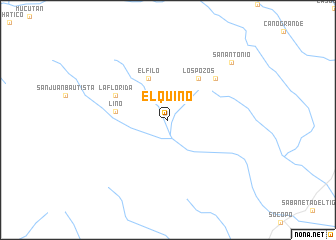
El Quino (Barinas, Venezuela)El Quino is a town in the Barinas region of Venezuela. An overview map of the region around El Quino is displayed below.
regional and 3d topo map of El Quino, Venezuela ::
El Quino airports ::
The nearest airport is MRD - Merida Alberto Carnevalli, located 36.7 km north west of El Quino.
Other airports nearby include BNS - Barinas (84.0 km east), VLV - Valera Dr Antonio Nicolas Briceno (116.9 km north), STB - Santa Barbara Del Zulia (131.5 km north west), AUC - Arauca Santiago Perez (142.4 km south), Nearby towns ::
El Filo (5.1km north west) //
Los Pozos (5.7km north east) //
Lino (5.8km west) //
Las Barrancas (6.4km north west) //
La Florida (6.4km north west) //
El Pegón (7.0km north east) //
San Antonio (9.6km north east) //
[all distances 'as the bird flies' and approximate] 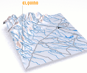 Places with similar names to El Quino, Venezuela ::
Disclaimer :: Information on this page comes without warranty of any kind |
||
|
Where is El Quino? Elevation and coordinates ::
Latitude (lat): 8°20'31"N Longitude (lon): 70°55'51"W
Elevation (approx.): 928m (map arrows pan, magnifying glasses zoom) |
||
|
Visiting El Quino? Hotel/Accommodation ::
Book a hotel in El Quino Travel Guide ::
Buy a travel guide for Venezuela rental cars ::
car rental offers GPS waypoint ::
download a GPX waypoint (PoI) of El Quino for your GPS receiver
|
||