|
search place name
|
||
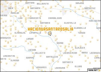
Hacienda Santa Rosalía (Miranda, Venezuela)Hacienda Santa Rosalía is a town in the Miranda region of Venezuela. An overview map of the region around Hacienda Santa Rosalía is displayed below.
regional and 3d topo map of Hacienda Santa Rosalía, Venezuela ::
Hacienda Santa Rosalía airports ::
The nearest airport is CCS - Caracas Simon Bolivar Intl, located 43.0 km north west of Hacienda Santa Rosalía.
Other airports nearby include VLN - Valencia Arturo Michelena Intl (140.6 km west), VDP - Valle De La Pascua (148.2 km south east), PBL - Puerto Cabello General Bartolome Salom Intl (154.4 km west), BLA - Barcelona General Jose Antonio Anzoategui Intl (218.8 km east), Nearby towns ::
La Lloviana (1.8km east) //
Trujillo (1.8km east) //
La Florida (1.9km north) //
Oficina Chaguarama (1.9km north) //
San José (1.9km north) //
San Vicente (2.2km north west) //
La Florida (2.4km south east) //
Arenaza (2.5km south east) //
El Remington (2.6km north west) //
Los Mangos (2.6km north west) //
La Lagunita (2.6km north west) //
La Constancia (4.1km north west) //
El Carmen (4.1km north west) //
Santa Ana (4.1km north west) //
Guime (4.1km north east) //
San Juan de Dios (4.9km south) //
El Sapo (5.0km south west) //
Helechal (5.1km north west) //
El Amarillo (5.2km south west) //
Dignao (5.2km south east) //
El Socorro (5.2km north east) //
Paradero (5.2km north east) //
La Preciosa (5.4km north east) //
Ochoa (5.5km north east) //
La Tortilla (5.5km west) //
La Envidia (5.5km west) //
Campo Alegre (5.9km north) //
La Quisanda (5.9km south) //
Las Mercedes (5.8km east) //
[all distances 'as the bird flies' and approximate]  Places with similar names to Hacienda Santa Rosalía, Venezuela :: Disclaimer :: Information on this page comes without warranty of any kind |
||
|
Where is Hacienda Santa Rosalía? Elevation and coordinates ::
Latitude (lat): 10°23'0"N Longitude (lon): 66°40'0"W
Elevation (approx.): 286m (map arrows pan, magnifying glasses zoom) |
||
|
Visiting Hacienda Santa Rosalía? Hotel/Accommodation ::
Book a hotel in Hacienda Santa Rosalía Travel Guide ::
Buy a travel guide for Venezuela rental cars ::
car rental offers GPS waypoint ::
download a GPX waypoint (PoI) of Hacienda Santa Rosalía for your GPS receiver
|
||