|
search place name
|
||
Lagunita (Carabobo, Venezuela)Lagunita is a town in the Carabobo region of Venezuela. An overview map of the region around Lagunita is displayed below.
regional and 3d topo map of Lagunita, Venezuela ::

Lagunita airports ::
The nearest airport is VLN - Valencia Arturo Michelena Intl, located 21.2 km north west of Lagunita.
Other airports nearby include PBL - Puerto Cabello General Bartolome Salom Intl (60.9 km north west), SFH - San Felipe Sub Teniente Nestor Arias (106.2 km west), CCS - Caracas Simon Bolivar Intl (115.0 km north east), AGV - Acarigua Oswaldo Guevara Mujica (161.2 km west), Nearby towns ::
Los Lagunazos (1.7km north east) //
Santa Inés (2.5km south) //
Copetón (2.8km north) //
El Aletón (3.1km north) //
Jabillal (3.2km west) //
La Candelaria (3.2km south) //
Pacaragua (3.7km south) //
Monte Esperanza (3.7km east) //
Manuare (4.1km south east) //
Carabobita (4.1km south east) //
Cecilia (4.1km north east) //
San Rafael de Pacaragua (4.4km south) //
Santa Efigenia (4.6km north east) //
El Veinticinco (5.7km north west) //
El Copey (5.7km north west) //
Palmiro (5.9km south) //
Santa Inés (5.9km south) //
El Cocuy (5.9km east) //
Pacaragua (6.1km south) //
Agua Blanca (6.1km north) //
Las Minas (6.2km north west) //
La Palma (6.3km north east) //
Altamira (6.3km north east) //
Riachón (6.6km south west) //
Los Naranjos (6.6km south west) //
Peñitas (6.7km north east) //
San Rafael (6.6km south east) //
Lagunita (7.4km south west) //
Aragüita (7.5km north east) //
[all distances 'as the bird flies' and approximate] 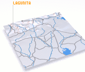 Places with similar names to Lagunita, Venezuela ::
Disclaimer :: Information on this page comes without warranty of any kind |
||
|
Where is Lagunita? Elevation and coordinates ::
Latitude (lat): 9°59'0"N Longitude (lon): 67°50'0"W
Elevation (approx.): 814m (map arrows pan, magnifying glasses zoom) |
||
|
Visiting Lagunita? Hotel/Accommodation ::
Book a hotel in Lagunita Travel Guide ::
Buy a travel guide for Venezuela rental cars ::
car rental offers GPS waypoint ::
download a GPX waypoint (PoI) of Lagunita for your GPS receiver
|
||