|
search place name
|
||
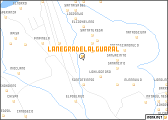
La Negra del Alguaral (Cojedes, Venezuela)La Negra del Alguaral is a town in the Cojedes region of Venezuela. An overview map of the region around La Negra del Alguaral is displayed below.
regional and 3d topo map of La Negra del Alguaral, Venezuela ::
La Negra del Alguaral airports ::
The nearest airport is AGV - Acarigua Oswaldo Guevara Mujica, located 39.1 km west of La Negra del Alguaral.
Other airports nearby include BRM - Barquisimeto Intl (78.1 km north west), SFH - San Felipe Sub Teniente Nestor Arias (85.5 km north), GUQ - Guanare (110.0 km south west), VLN - Valencia Arturo Michelena Intl (126.0 km north east), Nearby towns ::
Mata de Camoruco (2.6km north east) //
Mata Oscura (4.1km north east) //
Los Mangos (5.1km north east) //
La Milagrosa (5.2km south east) //
Santa Teresa (5.6km south) //
Santa Teresa (5.9km north) //
La Vega de Aguasal (6.6km north west) //
El Carmelero (7.4km north) //
San Jacinto (7.3km east) //
Samancito (7.5km east) //
El Estero (9.2km south east) //
[all distances 'as the bird flies' and approximate]  Places with similar names to La Negra del Alguaral, Venezuela :: Disclaimer :: Information on this page comes without warranty of any kind |
||
|
Where is La Negra del Alguaral? Elevation and coordinates ::
Latitude (lat): 9°31'0"N Longitude (lon): 68°53'0"W
Elevation (approx.): 118m (map arrows pan, magnifying glasses zoom) |
||
|
Visiting La Negra del Alguaral? Hotel/Accommodation ::
Book a hotel in La Negra del Alguaral Travel Guide ::
Buy a travel guide for Venezuela rental cars ::
car rental offers GPS waypoint ::
download a GPX waypoint (PoI) of La Negra del Alguaral for your GPS receiver
|
||