|
search place name
|
||
La Rosa (Falcón, Venezuela)La Rosa is a town in the Falcón region of Venezuela. An overview map of the region around La Rosa is displayed below.
regional and 3d topo map of La Rosa, Venezuela ::

La Rosa airports ::
The nearest airport is SFH - San Felipe Sub Teniente Nestor Arias, located 80.2 km south of La Rosa.
Other airports nearby include PBL - Puerto Cabello General Bartolome Salom Intl (101.1 km south east), CZE - Coro Jose Leonardo Chirinos (103.4 km north west), BRM - Barquisimeto Intl (120.5 km south west), CUR - Willemstad Hato (132.2 km north), Nearby towns ::
Las Piedras (0.8km north) //
Los Pavos (1.8km west) //
La Loma (3.6km east) //
San Antonio (3.7km north) //
Cerro Antonio (4.1km north) //
Marsillalita (4.1km north east) //
Santa Cruz (4.1km north west) //
Buenos Aires (4.3km south) //
Macanillal de Maporita (5.1km south east) //
Píritu de Jacura (5.2km north west) //
El Mene del Río (5.5km south) //
Quiragua (5.8km north) //
Quiriquire (7.6km north) //
Cruz de Aroa (7.6km north) //
Jacura (7.6km north) //
Santa Lucía (10.7km south east) //
[all distances 'as the bird flies' and approximate] 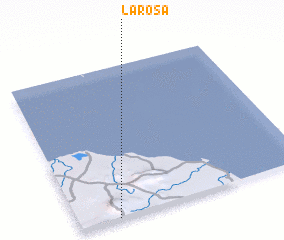 Places with similar names to La Rosa, Venezuela ::
Disclaimer :: Information on this page comes without warranty of any kind |
||
|
Where is La Rosa? Elevation and coordinates ::
Latitude (lat): 11°0'0"N Longitude (lon): 68°50'0"W
Elevation (approx.): 117m (map arrows pan, magnifying glasses zoom) |
||
|
Visiting La Rosa? Hotel/Accommodation ::
Book a hotel in La Rosa Travel Guide ::
Buy a travel guide for Venezuela rental cars ::
car rental offers GPS waypoint ::
download a GPX waypoint (PoI) of La Rosa for your GPS receiver
|
||