|
search place name
|
||
La Trampa (Sucre, Venezuela)La Trampa is a town in the Sucre region of Venezuela. An overview map of the region around La Trampa is displayed below.
regional and 3d topo map of La Trampa, Venezuela ::

La Trampa airports ::
The nearest airport is CUP - Carupano General Jose Francisco Bermudez, located 54.3 km north east of La Trampa.
Other airports nearby include CUM - Cumana Antonio Jose De Sucre (66.6 km west), MUN - Maturin (71.7 km south east), PMV - Porlamar Del Caribe Intl Gen Santiago Marino (85.1 km north west), BLA - Barcelona General Jose Antonio Anzoategui Intl (125.7 km west), Nearby towns ::
El Purgatorio (1.4km south) //
El Encanto (1.8km west) //
El Trancadero (2.0km north west) //
Palma Sola (2.3km east) //
La Loma (2.8km north) //
Pueblo Viejo (3.1km north west) //
Tierra Blanca (3.2km south) //
Los Lecheros (3.4km west) //
El Cantón (3.4km west) //
Los Mangos (3.7km west) //
Las Cocuizas (3.8km north west) //
El Naranjo (3.9km south east) //
Laberinto (3.9km north east) //
Paujicillo (3.9km south west) //
La Castaña (4.2km north west) //
Campo Florido (4.6km east) //
Las Vegas (4.6km west) //
Guatamare (4.9km west) //
Sabana de Piedra (5.1km south) //
Sabana Redonda (5.1km north) //
Juan Largo (5.1km south east) //
Los Altos (5.4km north west) //
La Guanota (5.5km south east) //
Boquerón (5.6km south) //
Altamira (5.6km south east) //
Santa María (5.7km north west) //
Alegría (5.8km west) //
El Tinaco (5.9km north west) //
Agua Caliente (6.5km north) //
[all distances 'as the bird flies' and approximate] 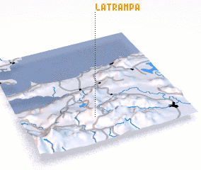 Places with similar names to La Trampa, Venezuela ::
Disclaimer :: Information on this page comes without warranty of any kind |
||
|
Where is La Trampa? Elevation and coordinates ::
Latitude (lat): 10°15'44"N Longitude (lon): 63°33'10"W
Elevation (approx.): 698m (map arrows pan, magnifying glasses zoom) |
||
|
Visiting La Trampa? Hotel/Accommodation ::
Book a hotel in La Trampa Travel Guide ::
Buy a travel guide for Venezuela rental cars ::
car rental offers GPS waypoint ::
download a GPX waypoint (PoI) of La Trampa for your GPS receiver
|
||