|
search place name
|
||
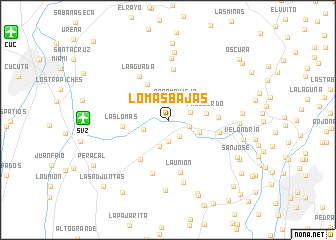
Lomas Bajas (Táchira, Venezuela)Lomas Bajas is a town in the Táchira region of Venezuela. An overview map of the region around Lomas Bajas is displayed below.
regional and 3d topo map of Lomas Bajas, Venezuela ::
Lomas Bajas airports ::
The nearest airport is SVZ - San Antonio Del Tachira, located 9.4 km west of Lomas Bajas.
Other airports nearby include CUC - Cucuta Camilo Daza (19.9 km north west), LFR - La Fria (45.2 km north), STD - Santo Domingo Mayor Buenaventura Vivas (46.5 km south east), BGA - Bucaramanga Palonegro (120.9 km south west), Nearby towns ::
Agua Fría (2.2km south east) //
Páramo Viejo (2.3km north east) //
Salado Negro (2.4km south) //
Salom (2.5km east) //
Lomas Altas (2.7km east) //
Casa Nueva (2.9km west) //
La Mulera (3.1km south) //
Libertad (3.8km east) //
La Fila (4.2km north west) //
Palo Gordo (4.4km east) //
Hato de La Virgen (4.5km north west) //
Las Lomas (5.0km west) //
Apartaderos (5.3km south west) //
Llano Grande (5.6km north) //
Cerro de La Laguna (5.6km east) //
La Aguada (5.8km north west) //
Independencia (5.9km east) //
La Unión (6.0km south) //
El Recreo (6.3km south) //
Los Picachitos (6.8km north) //
El Cerro (7.2km south) //
Peñas Negras (7.6km north) //
Caña Brava (7.9km south) //
Peribeca (7.9km east) //
El Topón (8.3km east) //
El Laurel (8.6km north) //
Velandria (8.7km east) //
Las Guamas (8.8km south) //
San José (8.8km south east) //
[all distances 'as the bird flies' and approximate]  Places with similar names to Lomas Bajas, Venezuela :: Disclaimer :: Information on this page comes without warranty of any kind |
||
|
Where is Lomas Bajas? Elevation and coordinates ::
Latitude (lat): 7°50'22"N Longitude (lon): 72°21'17"W
Elevation (approx.): 1008m (map arrows pan, magnifying glasses zoom) |
||
|
Visiting Lomas Bajas? Hotel/Accommodation ::
Book a hotel in Lomas Bajas Travel Guide ::
Buy a travel guide for Venezuela rental cars ::
car rental offers GPS waypoint ::
download a GPX waypoint (PoI) of Lomas Bajas for your GPS receiver
|
||