|
search place name
|
||
Playa Nueva (Zulia, Venezuela)Playa Nueva is a town in the Zulia region of Venezuela. An overview map of the region around Playa Nueva is displayed below.
regional and 3d topo map of Playa Nueva, Venezuela ::

Playa Nueva airports ::
The nearest airport is STB - Santa Barbara Del Zulia, located 38.6 km east of Playa Nueva.
Other airports nearby include LFR - La Fria (91.4 km south), CUC - Cucuta Camilo Daza (128.4 km south), MRD - Merida Alberto Carnevalli (134.4 km south east), SVZ - San Antonio Del Tachira (136.6 km south), Nearby towns ::
Boca del Zulia (2.2km south west) //
Cabimitas (2.9km west) //
Vuelta del Cojo (3.7km south west) //
Las Bostas (4.3km west) //
Encontrados (5.5km east) //
Los Guasimos (7.6km north west) //
La India (8.3km south east) //
El Cedro (11.1km north east) //
[all distances 'as the bird flies' and approximate] 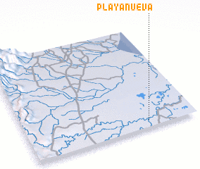 Places with similar names to Playa Nueva, Venezuela ::
// Polyanovo (BG)
// Polyanovo (BG)
// Playa Nueva (CO)
// Poluyanovo (RU)
// Poluyanovo (RU)
// Poluyanovo (RU)
// Poluyanovo (RU)
// Pol'yanovo (RU)
// Pol'yanovo (RU)
// Poluyanovo (BY)
Disclaimer :: Information on this page comes without warranty of any kind |
||
|
Where is Playa Nueva? Elevation and coordinates ::
Latitude (lat): 9°3'56"N Longitude (lon): 72°16'54"W
Elevation (approx.): 11m (map arrows pan, magnifying glasses zoom) |
||
|
Visiting Playa Nueva? Hotel/Accommodation ::
Book a hotel in Playa Nueva Travel Guide ::
Buy a travel guide for Venezuela rental cars ::
car rental offers GPS waypoint ::
download a GPX waypoint (PoI) of Playa Nueva for your GPS receiver
|
||