|
search place name
|
||
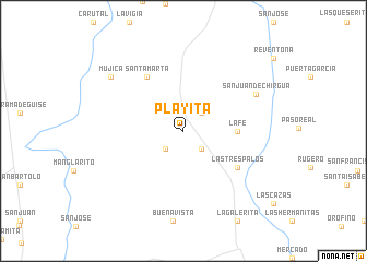
Playita (Cojedes, Venezuela)Playita is a town in the Cojedes region of Venezuela. An overview map of the region around Playita is displayed below.
regional and 3d topo map of Playita, Venezuela ::
Playita airports ::
The nearest airport is VLN - Valencia Arturo Michelena Intl, located 87.0 km north of Playita.
Other airports nearby include PBL - Puerto Cabello General Bartolome Salom Intl (123.5 km north), SFH - San Felipe Sub Teniente Nestor Arias (130.5 km north west), AGV - Acarigua Oswaldo Guevara Mujica (137.5 km west), BRM - Barquisimeto Intl (166.8 km north west), Nearby towns ::
Lo Increíble (2.6km north east) //
Hato Hondo (2.6km south west) //
Morguito (2.6km south east) //
La Fe (5.5km east) //
Santa Marta (6.7km north west) //
Las Tres Palos (6.6km south east) //
San Juan de Chirgua (8.2km north east) //
Mujica (9.2km north west) //
[all distances 'as the bird flies' and approximate]  Places with similar names to Playita, Venezuela ::
// Playita (PA)
// Pelayito (CO)
// Playeta (CO)
// Pāliyād (IN)
// Palaiyuttu (LK)
// Palliyadda (LK)
// Puliyadda (LK)
// Playita (US)
// Playita (US)
// Plei Ya Té (VN)
Disclaimer :: Information on this page comes without warranty of any kind |
||
|
Where is Playita? Elevation and coordinates ::
Latitude (lat): 9°22'0"N Longitude (lon): 68°0'0"W
Elevation (approx.): 119m (map arrows pan, magnifying glasses zoom) |
||
|
Visiting Playita? Hotel/Accommodation ::
Book a hotel in Playita Travel Guide ::
Buy a travel guide for Venezuela rental cars ::
car rental offers GPS waypoint ::
download a GPX waypoint (PoI) of Playita for your GPS receiver
|
||