|
search place name
|
||
Demba Njai Ya (Western, Gambia, The)Demba Njai Ya is a town in the Western region of Gambia, The. An overview map of the region around Demba Njai Ya is displayed below.
regional and 3d topo map of Demba Njai Ya, Gambia, The ::

Demba Njai Ya airports ::
The nearest airport is BJL - Banjul Intl, located 11.7 km north of Demba Njai Ya.
Other airports nearby include ZIG - Ziguinchor (83.9 km south east), CSK - Cap Skiring (92.5 km south), KLC - Kaolack (118.0 km north east), BXO - Bissau Oswaldo Vieira Intl (181.9 km south east), Nearby towns ::
Sare Jutah (2.0km north west) //
Manduar (2.0km north west) //
Penjem (2.3km south) //
Jamwelly (2.5km north west) //
Bakary Sambou (2.6km west) //
Dewru (3.0km north) //
Bajong Koto (3.2km west) //
Tubakuta (3.3km north east) //
Basori (3.3km east) //
Modouya (3.4km south west) //
Fula Kunda (3.8km north) //
Madina (3.7km north west) //
Marakissa (4.3km south west) //
Brikama (4.4km north west) //
Jalambantang (4.6km south) //
Madina Talakoto (4.8km south east) //
Kiti Manjago (5.0km west) //
Kiti (5.0km west) //
Sabu Kunda (5.2km north) //
Leese Ya (5.1km south west) //
Mansal (5.2km west) //
Kaimbujae NDing (5.3km north) //
Kabekel (5.5km south west) //
Sere Kunda NDing (5.6km north) //
Nila Koto (5.6km north west) //
Mandinaba (5.7km north east) //
Jida (6.0km south east) //
Busura (6.3km south) //
Kuloro (6.7km north east) //
[all distances 'as the bird flies' and approximate] 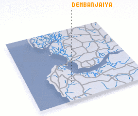 Places with similar names to Demba Njai Ya, Gambia, The ::
Disclaimer :: Information on this page comes without warranty of any kind |
||
|
Where is Demba Njai Ya? Elevation and coordinates ::
Latitude (lat): 13°14'13"N Longitude (lon): 16°37'14"W
Elevation (approx.): 24m (map arrows pan, magnifying glasses zoom) |
||
|
Visiting Demba Njai Ya? Hotel/Accommodation ::
Book a hotel in Demba Njai Ya Travel Guide ::
Buy a travel guide for Gambia, The rental cars ::
car rental offers GPS waypoint ::
download a GPX waypoint (PoI) of Demba Njai Ya for your GPS receiver
|
||