|
search place name
|
||
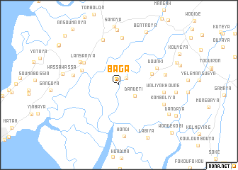
Baga (Guinea)Baga is a town in Guinea. An overview map of the region around Baga is displayed below.
regional and 3d topo map of Baga, Guinea ::
Baga airports ::
The nearest airport is FIG - Fira Fria, located 80.6 km north of Baga.
Other airports nearby include FNA - Freetown Lungi (116.1 km south), LEK - Labe (228.9 km north east), Nearby towns ::
Kaki (1.6km north east) //
Dandeti (3.0km south east) //
Salam (5.4km east) //
Kissamondéya (6.2km west) //
Dounki (6.4km north east) //
Lansaniya (6.5km north west) //
Kokoma (7.0km north west) //
Waliyakhouré (7.1km east) //
Tomboléya (7.2km west) //
Kassaniya (7.5km north) //
Massaya (7.4km east) //
Kountouya (7.5km north) //
Kambaliya (7.7km south east) //
Wondi (8.1km south) //
Wendima (8.7km north) //
Wassawassa (8.9km west) //
Kaléma (9.0km south east) //
Bentroya (9.4km north east) //
Labiya (9.4km south east) //
Wondékobi (11.2km south east) //
Ansoumanya (11.3km north west) //
Tamatara (11.5km north west) //
[all distances 'as the bird flies' and approximate] 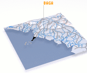 Places with similar names to Baga, Guinea ::
Disclaimer :: Information on this page comes without warranty of any kind |
||
|
Where is Baga? Elevation and coordinates ::
Latitude (lat): 9°37'38"N Longitude (lon): 13°28'51"W
Elevation (approx.): 4m (map arrows pan, magnifying glasses zoom) |
||
|
Visiting Baga? Hotel/Accommodation ::
Book a hotel in Baga Travel Guide ::
Buy a travel guide for Guinea rental cars ::
car rental offers GPS waypoint ::
download a GPX waypoint (PoI) of Baga for your GPS receiver
|
||