|
search place name
|
||
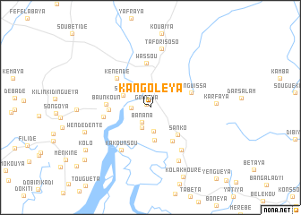
Kangoléya (Guinea)Kangoléya is a town in Guinea. An overview map of the region around Kangoléya is displayed below.
regional and 3d topo map of Kangoléya, Guinea ::
Kangoléya airports ::
The nearest airport is FIG - Fira Fria, located 41.4 km north of Kangoléya.
Other airports nearby include FNA - Freetown Lungi (159.1 km south), LEK - Labe (210.1 km north east), Nearby towns ::
Gomézia (0.7km north west) //
Banana (2.1km south west) //
Fafendé (2.3km west) //
Maniokhoun (2.7km south west) //
Souguébunyi (2.9km south) //
Songa (3.6km north west) //
Saféya (4.1km south) //
Sanko (4.8km south east) //
Koléya (4.9km south east) //
Sonkolou (5.1km west) //
Yenguissa (5.3km east) //
Wassou (5.5km north) //
Kénendé (5.5km north west) //
Baunkoun (5.5km west) //
Wawa (5.8km west) //
Kakounsou (6.4km south west) //
Banfou (6.6km south east) //
Tafori Soso (7.5km north) //
Taban (7.5km south east) //
Karfaya (8.1km east) //
Wendédenté (8.6km west) //
Kolakhouré (9.6km south east) //
Kolo (9.5km south west) //
Sayonya (10.4km south west) //
Yenguéya (12.0km south east) //
[all distances 'as the bird flies' and approximate]  Places with similar names to Kangoléya, Guinea ::
// Congluoyu (CN)
Disclaimer :: Information on this page comes without warranty of any kind |
||
|
Where is Kangoléya? Elevation and coordinates ::
Latitude (lat): 9°59'2"N Longitude (lon): 13°38'44"W
Elevation (approx.): 14m (map arrows pan, magnifying glasses zoom) |
||
|
Visiting Kangoléya? Hotel/Accommodation ::
Book a hotel in Kangoléya Travel Guide ::
Buy a travel guide for Guinea rental cars ::
car rental offers GPS waypoint ::
download a GPX waypoint (PoI) of Kangoléya for your GPS receiver
|
||