|
search place name
|
||
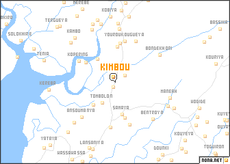
Kimbou (Guinea)Kimbou is a town in Guinea. An overview map of the region around Kimbou is displayed below.
regional and 3d topo map of Kimbou, Guinea ::
Kimbou airports ::
The nearest airport is FIG - Fira Fria, located 66.1 km north of Kimbou.
Other airports nearby include FNA - Freetown Lungi (130.5 km south), LEK - Labe (218.4 km north east), Nearby towns ::
Kaguélé (0.8km south) //
Sangaréya (1.9km north east) //
Kénendé (2.2km north east) //
Tombolon (4.0km south west) //
Dubréka (4.7km north west) //
Kirikira (5.1km south west) //
Samaya (5.4km south) //
Tanéné (5.8km north) //
Dofili (5.7km north west) //
Wendima (6.0km south) //
Béréyiré (6.4km north) //
Kopéring (6.7km north west) //
Youroukouguéya (6.8km north) //
Kassaniya (7.4km south) //
Kountouya (7.4km south) //
Simbaya (7.4km north east) //
Ansoumanya (7.9km south west) //
Bondékhori (8.5km north east) //
Bentroya (8.6km south east) //
Tersey (8.7km north) //
Borondou (9.2km north west) //
Tamatara (9.3km south west) //
Friguiadi (9.5km south east) //
Dentéforé (9.6km north west) //
Kambo (9.6km north west) //
Tamouta (11.1km south west) //
Basseniaïa (11.2km south west) //
[all distances 'as the bird flies' and approximate] 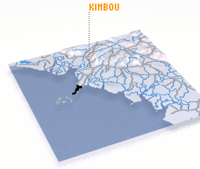 Places with similar names to Kimbou, Guinea ::
Disclaimer :: Information on this page comes without warranty of any kind |
||
|
Where is Kimbou? Elevation and coordinates ::
Latitude (lat): 9°45'26"N Longitude (lon): 13°29'52"W
Elevation (approx.): 16m (map arrows pan, magnifying glasses zoom) |
||
|
Visiting Kimbou? Hotel/Accommodation ::
Book a hotel in Kimbou Travel Guide ::
Buy a travel guide for Guinea rental cars ::
car rental offers GPS waypoint ::
download a GPX waypoint (PoI) of Kimbou for your GPS receiver
|
||