|
search place name
|
||
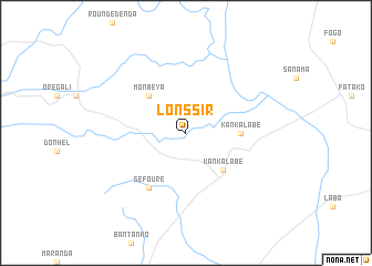
Lonssir (Dalaba, Guinea)Lonssir is a town in the Dalaba region of Guinea. An overview map of the region around Lonssir is displayed below.
regional and 3d topo map of Lonssir, Guinea ::
Lonssir airports ::
The nearest airport is LEK - Labe, located 31.9 km north west of Lonssir.
Other airports nearby include KGG - Kedougou (155.0 km north), FAA - Faranah (187.7 km south east), FIG - Fira Fria (191.6 km south west), Nearby towns ::
 Places with similar names to Lonssir, Guinea ::
// Lansar (MA)
// Lansyr' (RU)
// Lancer (US)
// La Inesera (CO)
// Lanacera (CO)
// Lunsar (IN)
// Lunsira (IN)
// Linséré (GN)
// Linsoro (GN)
// Laaw Nasarow (SO)
Disclaimer :: Information on this page comes without warranty of any kind |
||
|
Where is Lonssir? Elevation and coordinates ::
Latitude (lat): 11°11'0"N Longitude (lon): 12°2'0"W
Elevation (approx.): 675m (map arrows pan, magnifying glasses zoom) |
||
|
Visiting Lonssir? Hotel/Accommodation ::
Book a hotel in Lonssir Travel Guide ::
Buy a travel guide for Guinea rental cars ::
car rental offers GPS waypoint ::
download a GPX waypoint (PoI) of Lonssir for your GPS receiver
|
||