|
search place name
|
||
Āl Bū Mu‘ayţ (Dayr az Zawr, Syria)Āl Bū Mu‘ayţ is a town in the Dayr az Zawr region of Syria. An overview map of the region around Āl Bū Mu‘ayţ is displayed below.
regional and 3d topo map of Āl Bū Mu‘ayţ, Syria ::

Āl Bū Mu‘ayţ airports ::
The nearest airport is DEZ - Deire Zor Deir Zzor, located 13.4 km west of Āl Bū Mu‘ayţ.
Other airports nearby include PMS - Palmyra (198.3 km west), Nearby towns ::
Muḩaşşah (0.0km north) //
Muḩassan (2.4km south east) //
Aţ Ţābiyah (2.4km north west) //
Aţ Ţābiyah (2.4km south west) //
Sa‘dūnī (3.0km east) //
Daḩlah (3.5km south east) //
Jadīd Bū Khayr (4.8km south east) //
Jadīd ‘Uqaydāt (4.8km south east) //
Abū Layl (4.8km south east) //
Khushām (4.9km west) //
Aţ Ţābiyah (4.9km west) //
Abū ‘Amr (6.1km west) //
[all distances 'as the bird flies' and approximate] 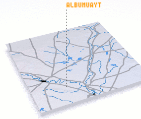 Places with similar names to Āl Bū Mu‘ayţ, Syria ::
// Alabameta (NG)
Disclaimer :: Information on this page comes without warranty of any kind |
||
|
Where is Āl Bū Mu‘ayţ? Elevation and coordinates ::
Latitude (lat): 35°15'0"N Longitude (lon): 40°19'0"E
Elevation (approx.): 197m (map arrows pan, magnifying glasses zoom) |
||
|
Visiting Āl Bū Mu‘ayţ? Hotel/Accommodation ::
Book a hotel in Āl Bū Mu‘ayţ Travel Guide ::
Buy a travel guide for Syria rental cars ::
car rental offers GPS waypoint ::
download a GPX waypoint (PoI) of Āl Bū Mu‘ayţ for your GPS receiver
|
||