|
search place name
|
||
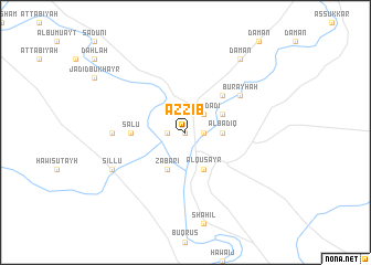
Az Zīb (Dayr az Zawr, Syria)Az Zīb is a town in the Dayr az Zawr region of Syria. An overview map of the region around Az Zīb is displayed below.
regional and 3d topo map of Az Zīb, Syria ::
Az Zīb airports ::
The nearest airport is DEZ - Deire Zor Deir Zzor, located 26.9 km north west of Az Zīb.
Nearby towns ::
Al Ḩayawān (0.0km north) //
Al Buşayrah (1.5km west) //
Al Fulayt (1.5km west) //
Rashīdah (1.5km east) //
Al Mişrī (1.5km east) //
Baghdādī (2.4km north east) //
Al Badīq (3.0km east) //
‘Alī ash Shahl (3.6km north east) //
Aţ Ţuwaymīyah (3.6km north east) //
Ruwayḩah (4.0km south) //
Zabārī (4.0km south) //
Al Quşayr (4.0km south) //
Al Khān (4.8km north east) //
Sa‘lū (4.5km west) //
Burayḩah (5.9km north east) //
Rumayl (5.9km north east) //
Qaţ‘ah (6.1km west) //
Sillū (7.1km south west) //
Damān (8.7km north east) //
[all distances 'as the bird flies' and approximate]  Places with similar names to Az Zīb, Syria ::
Disclaimer :: Information on this page comes without warranty of any kind |
||
|
Where is Az Zīb? Elevation and coordinates ::
Latitude (lat): 35°10'0"N Longitude (lon): 40°26'0"E
Elevation (approx.): 192m (map arrows pan, magnifying glasses zoom) |
||
|
Visiting Az Zīb? Hotel/Accommodation ::
Book a hotel in Az Zīb Travel Guide ::
Buy a travel guide for Syria rental cars ::
car rental offers GPS waypoint ::
download a GPX waypoint (PoI) of Az Zīb for your GPS receiver
|
||