|
search place name
|
||
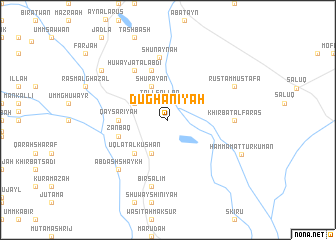
Dūghānīyah (Ar Raqqah, Syria)Dūghānīyah is a town in the Ar Raqqah region of Syria. An overview map of the region around Dūghānīyah is displayed below.
regional and 3d topo map of Dūghānīyah, Syria ::
Dūghānīyah airports ::
The nearest airport is GZT - Gaziantep Oguzeli, located 142.3 km west of Dūghānīyah.
Other airports nearby include ALP - Aleppo Intl (165.0 km west), DEZ - Deire Zor Deir Zzor (177.4 km south east), DIY - Diyabakir Diyarbakir (181.8 km north east), MLX - Malatya Erhac (222.4 km north), Nearby towns ::
Tall Sallān (2.3km north) //
Khirbat ar Ruzz (3.5km north west) //
Shuray‘ān (4.0km north) //
‘Alī Bajlīyah (4.0km south) //
‘Uqlat al Kūshān (4.8km south west) //
Qayşarīyah (4.5km west) //
Zanbāq (4.8km south west) //
Shanīnah (5.8km north) //
Ḩuwayjat al ‘Abdī (6.3km north west) //
Shunaynah (7.0km north) //
Khirbat al Faras (6.0km east) //
Biʼr Sālim (7.6km south) //
‘Abd ash Shaykh (7.1km south west) //
Rustam Muşţafá (7.0km north east) //
Ḩammām at Turkumān (7.6km south east) //
Laqtah (8.1km north west) //
[all distances 'as the bird flies' and approximate]  Places with similar names to Dūghānīyah, Syria ::
Disclaimer :: Information on this page comes without warranty of any kind |
||
|
Where is Dūghānīyah? Elevation and coordinates ::
Latitude (lat): 36°34'0"N Longitude (lon): 39°0'0"E
Elevation (approx.): 329m (map arrows pan, magnifying glasses zoom) |
||
|
Visiting Dūghānīyah? Hotel/Accommodation ::
Book a hotel in Dūghānīyah Travel Guide ::
Buy a travel guide for Syria rental cars ::
car rental offers GPS waypoint ::
download a GPX waypoint (PoI) of Dūghānīyah for your GPS receiver
|
||