|
search place name
|
||
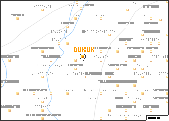
Dukūk (Al Ḩasakah, Syria)Dukūk is a town in the Al Ḩasakah region of Syria. An overview map of the region around Dukūk is displayed below.
regional and 3d topo map of Dukūk, Syria ::
Dukūk airports ::
The nearest airport is DIY - Diyabakir Diyarbakir, located 111.9 km north of Dukūk.
Other airports nearby include BAL - Batman (129.9 km north east), DEZ - Deire Zor Deir Zzor (180.5 km south), EZS - Elazig (213.8 km north west), Nearby towns ::
Bayramīyah (1.5km west) //
Judaydat Ḩarb (2.4km north east) //
Farḩīyah (2.4km south west) //
Umm ‘Ayyāsh al Fawqānī (3.7km south) //
Ḩajjīyah (3.0km east) //
Tall Dabash (3.5km north east) //
Kasrah (4.7km north west) //
Shawārighah (5.8km north) //
Bīrak (5.8km south east) //
Tall Amīr (5.8km north west) //
Tall Harmal (5.9km west) //
Sharafīyah (6.2km east) //
Burj (6.2km east) //
Buşayş al Fawqānī (6.2km west) //
Tall Dhiʼāb (7.1km north west) //
Tawrāh (7.1km north east) //
Tall ash Shūr al Gharbī (8.0km south) //
Judaydah (8.0km south) //
Faqīrah (8.0km north) //
Tall ash Shūr ash Sharqī (8.1km south east) //
Khirbat ash Sharqīyah (9.5km south west) //
[all distances 'as the bird flies' and approximate]  Places with similar names to Dukūk, Syria ::
Disclaimer :: Information on this page comes without warranty of any kind |
||
|
Where is Dukūk? Elevation and coordinates ::
Latitude (lat): 36°54'0"N Longitude (lon): 40°25'0"E
Elevation (approx.): 409m (map arrows pan, magnifying glasses zoom) |
||
|
Visiting Dukūk? Hotel/Accommodation ::
Book a hotel in Dukūk Travel Guide ::
Buy a travel guide for Syria rental cars ::
car rental offers GPS waypoint ::
download a GPX waypoint (PoI) of Dukūk for your GPS receiver
|
||