|
search place name
|
||
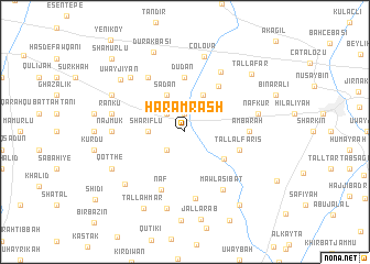
Ḩaram Rāsh (Al Ḩasakah, Syria)Ḩaram Rāsh is a town in the Al Ḩasakah region of Syria. An overview map of the region around Ḩaram Rāsh is displayed below.
regional and 3d topo map of Ḩaram Rāsh, Syria ::
Ḩaram Rāsh airports ::
The nearest airport is BAL - Batman, located 99.4 km north of Ḩaram Rāsh.
Other airports nearby include DIY - Diyabakir Diyarbakir (124.3 km north west), DEZ - Deire Zor Deir Zzor (211.0 km south west), EZS - Elazig (236.3 km north west), Nearby towns ::
Ḩaram Shaykhū (1.9km north) //
Aali Farro (2.4km south west) //
Balliqīyah (2.4km north west) //
Sharīflū (3.0km west) //
Tall Sha‘īr (4.0km north) //
Sadān (4.0km north) //
Naqqārah (4.2km south east) //
Dūdān (5.6km north) //
Kūdū (5.4km north east) //
Tall al Fāris (4.8km south east) //
Nāf (6.1km south) //
‘Ambārah (5.2km east) //
Tall Kayf (6.3km north west) //
Suhayr Makkah (6.8km south) //
Mawlá Sibāţ (6.6km south east) //
Kharāb Kurd (6.7km north east) //
Najmūk (5.9km west) //
Nāf Kūr (6.2km east) //
Ḩīmū (6.2km east) //
Rankū (6.2km west) //
Tūkī (7.1km north west) //
Çölova (7.8km north) //
Karī Sūd (7.9km south) //
Kūtiyān (7.2km south west) //
Qotthé (7.0km south west) //
Bāb al Khayr (7.0km north west) //
Uwayjıyān (7.4km north west) //
Durakbaşı (8.4km north) //
TallAḩmar (8.4km south west) //
[all distances 'as the bird flies' and approximate] 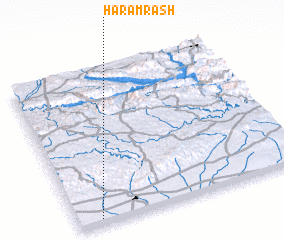 Places with similar names to Ḩaram Rāsh, Syria ::
// Ḩaram Rāsh (SY)
// Ḩaram Rāsh (SY)
Disclaimer :: Information on this page comes without warranty of any kind |
||
|
Where is Ḩaram Rāsh? Elevation and coordinates ::
Latitude (lat): 37°2'0"N Longitude (lon): 41°6'0"E
Elevation (approx.): 448m (map arrows pan, magnifying glasses zoom) |
||
|
Visiting Ḩaram Rāsh? Hotel/Accommodation ::
Book a hotel in Ḩaram Rāsh Travel Guide ::
Buy a travel guide for Syria rental cars ::
car rental offers GPS waypoint ::
download a GPX waypoint (PoI) of Ḩaram Rāsh for your GPS receiver
|
||