|
search place name
|
||
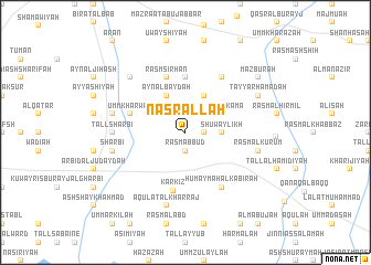
Naşr Allāh (Ḩalab, Syria)Naşr Allāh is a town in the Ḩalab region of Syria. An overview map of the region around Naşr Allāh is displayed below.
regional and 3d topo map of Naşr Allāh, Syria ::
Naşr Allāh airports ::
The nearest airport is ALP - Aleppo Intl, located 35.5 km west of Naşr Allāh.
Other airports nearby include GZT - Gaziantep Oguzeli (82.0 km north), LTK - Latakia Bassel Al Assad Intl (175.8 km south west), PMS - Palmyra (194.8 km south), Nearby towns ::
Rasm al Kabīr (1.5km east) //
Bījān (1.9km north) //
Rasm ‘Abbūd (1.9km south) //
Surayb (2.4km north west) //
Shuwaylīkh (3.0km east) //
Rasm al Kamā (3.5km north east) //
Tall Bījān (4.0km north) //
‘Ayn al Bayḑah (4.0km north) //
Khirbat al Jiḩāsh (5.6km north) //
Umm Kharwah (4.9km west) //
Rasm Sirḩān (5.8km north) //
Karkīz (6.0km south) //
Ḩumaymah al Kabīrah (6.3km south east) //
Mashrafat Abū Jabbār (6.3km north east) //
Tall Sharbī‘ (6.0km west) //
Rasm al Kurūm (6.3km east) //
Jurūf (6.3km west) //
‘Āqūlat al Kharrāj (7.6km south) //
‘Arbīd (6.3km west) //
Sharbī‘ (6.3km west) //
Multafitah (7.1km north west) //
Ţayyār Ḩamādah (7.0km north east) //
Mazbūrah (8.2km north east) //
[all distances 'as the bird flies' and approximate]  Places with similar names to Naşr Allāh, Syria ::
Disclaimer :: Information on this page comes without warranty of any kind |
||
|
Where is Naşr Allāh? Elevation and coordinates ::
Latitude (lat): 36°13'0"N Longitude (lon): 37°37'0"E
Elevation (approx.): 374m (map arrows pan, magnifying glasses zoom) |
||
|
Visiting Naşr Allāh? Hotel/Accommodation ::
Book a hotel in Naşr Allāh Travel Guide ::
Buy a travel guide for Syria rental cars ::
car rental offers GPS waypoint ::
download a GPX waypoint (PoI) of Naşr Allāh for your GPS receiver
|
||