|
search place name
|
||
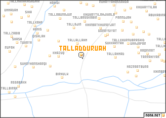
Tall ad Durū‘ah (Al Ḩasakah, Syria)Tall ad Durū‘ah is a town in the Al Ḩasakah region of Syria. An overview map of the region around Tall ad Durū‘ah is displayed below.
regional and 3d topo map of Tall ad Durū‘ah, Syria ::
Tall ad Durū‘ah airports ::
The nearest airport is BAL - Batman, located 134.9 km north of Tall ad Durū‘ah.
Other airports nearby include DIY - Diyabakir Diyarbakir (159.5 km north west), DEZ - Deire Zor Deir Zzor (185.3 km south west), EZS - Elazig (270.8 km north west), Nearby towns ::
Tall al Laḩm (3.6km north) //
Tall ‘Iz̧ām (3.5km north west) //
Khāzūq (4.4km west) //
Biʼr Ḩulw (5.7km south west) //
Abū Ḩujayrah (5.9km north west) //
Tall ‘Ajīn (7.2km north) //
Tall Aḩmad (5.9km east) //
Qudaymīyah (6.7km north east) //
KhirbatShīḩā (6.0km west) //
Khirbat ‘Aţshān (6.2km west) //
Sukkarīyah (6.4km north east) //
Duraysīyāt (7.1km north east) //
Khirbat Khurayjāt (7.6km north east) //
Tall Başş Kabīr (8.5km north) //
Khirab Suwayfāt (9.1km north west) //
[all distances 'as the bird flies' and approximate]  Places with similar names to Tall ad Durū‘ah, Syria ::
// Tolleterau (AT)
// Dilitor (HU)
// Dealu Ederii (RO)
// Daldere (TR)
// Daldere (TR)
// Doludere (TR)
// Doludere (TR)
// Delādar (IR)
// De Loutre (US)
// Delduār (BD)
Disclaimer :: Information on this page comes without warranty of any kind |
||
|
Where is Tall ad Durū‘ah? Elevation and coordinates ::
Latitude (lat): 36°43'2"N Longitude (lon): 41°14'1"E
Elevation (approx.): 336m (map arrows pan, magnifying glasses zoom) |
||
|
Visiting Tall ad Durū‘ah? Hotel/Accommodation ::
Book a hotel in Tall ad Durū‘ah Travel Guide ::
Buy a travel guide for Syria rental cars ::
car rental offers GPS waypoint ::
download a GPX waypoint (PoI) of Tall ad Durū‘ah for your GPS receiver
|
||