|
search place name
|
||
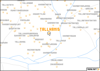
Tall Ḩamīs (Al Ḩasakah, Syria)Tall Ḩamīs is a town in the Al Ḩasakah region of Syria. An overview map of the region around Tall Ḩamīs is displayed below.
regional and 3d topo map of Tall Ḩamīs, Syria ::
Tall Ḩamīs airports ::
The nearest airport is BAL - Batman, located 133.2 km north of Tall Ḩamīs.
Other airports nearby include DIY - Diyabakir Diyarbakir (165.6 km north west), DEZ - Deire Zor Deir Zzor (196.4 km south west), VAN - Van (255.9 km north east), Nearby towns ::
Tall Ḩanwah (1.5km south) //
Khirbat Jassah Şaghīr (2.8km south) //
Ḩaşāwīyah (3.4km north west) //
Ghanāmīyah (4.0km north) //
Ţarājīyah (4.0km south) //
Khirbat Jassah (4.2km south) //
Maqrīnāt (4.1km south west) //
Tall Khiḑr (4.3km south east) //
Ḩannāwīyah Ḩaḑarīyah (4.7km north east) //
Ţarrāḩīyah (4.8km south west) //
Ḩusaynīyah (4.5km north west) //
Abū Kabīrah (5.6km north) //
Khirbat Ḩayshī (5.5km south) //
Umm Ja‘far (4.9km west) //
Khirbat Shīḩā (5.2km south west) //
Ḩulwah (6.1km north west) //
Khirbat ad Dīb (5.9km east) //
Khirbat Nūrah (7.4km south) //
Şāliḩīyat Ḩarb (6.1km west) //
Shūrā (7.5km north) //
Ash Shaykh Aḩmad (7.1km north east) //
Ḩaşāwīyah Fawqānī (7.1km north east) //
Tall Khurnūb Rashīd (6.6km west) //
Ḩaşawīyah Taḩtānī (7.0km north east) //
Khuwaytilah (7.9km north west) //
Mazra‘at Būrā (7.9km south west) //
Duwaysh (7.7km north west) //
Tall Abū Tuwaynah (9.1km north) //
Mujaddarah (9.2km south west) //
[all distances 'as the bird flies' and approximate] 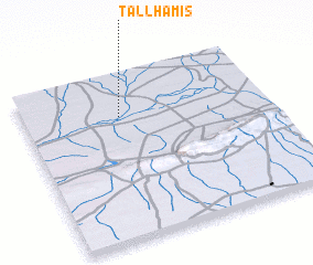 Places with similar names to Tall Ḩamīs, Syria :: Disclaimer :: Information on this page comes without warranty of any kind |
||
|
Where is Tall Ḩamīs? Elevation and coordinates ::
Latitude (lat): 36°45'0"N Longitude (lon): 41°24'0"E
Elevation (approx.): 348m (map arrows pan, magnifying glasses zoom) |
||
|
Visiting Tall Ḩamīs? Hotel/Accommodation ::
Book a hotel in Tall Ḩamīs Travel Guide ::
Buy a travel guide for Syria rental cars ::
car rental offers GPS waypoint ::
download a GPX waypoint (PoI) of Tall Ḩamīs for your GPS receiver
|
||