|
search place name
|
||
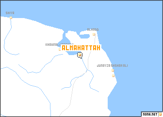
Al Maḩaţţah (Ash Sharqīyah, Oman)Al Maḩaţţah is a town in the Ash Sharqīyah region of Oman. An overview map of the region around Al Maḩaţţah is displayed below.
regional and 3d topo map of Al Maḩaţţah, Oman ::
Al Maḩaţţah airports ::
The nearest airport is MCT - Muscat Seeb Intl, located 195.8 km north west of Al Maḩaţţah.
Other airports nearby include MSH - Masirah (218.7 km south west), Nearby towns ::
Khawr al Jarāmah (5.0km north west) //
Al Ḩadd (6.1km north east) //
Junayz ash Shamālī (7.2km south east) //
Junayz al Janūbī (7.8km south east) //
[all distances 'as the bird flies' and approximate] 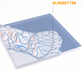 Places with similar names to Al Maḩaţţah, Oman ::
// Al Muḩawwaţah (IQ)
// Al Maḩaţţah (LB)
// Al Maḩaţţah (SA)
// Al Maḩaţţah (JO)
// Al Maḩadah (YE)
// Al Maḩaţţah (LB)
// Al Maḩaţţah (LB)
// Al Maḩaţţah (LB)
// Al Maḩaţţah (YE)
// Alambihud (PH)
Disclaimer :: Information on this page comes without warranty of any kind |
||
|
Where is Al Maḩaţţah? Elevation and coordinates ::
Latitude (lat): 22°28'25"N Longitude (lon): 59°45'47"E
Elevation (approx.): 6m (map arrows pan, magnifying glasses zoom) |
||
|
Visiting Al Maḩaţţah? Hotel/Accommodation ::
Book a hotel in Al Maḩaţţah Travel Guide ::
Buy a travel guide for Oman rental cars ::
car rental offers GPS waypoint ::
download a GPX waypoint (PoI) of Al Maḩaţţah for your GPS receiver
|
||