|
search place name
|
||
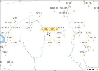
Angbasa (Gongola, Nigeria)Angbasa is a town in the Gongola region of Nigeria. An overview map of the region around Angbasa is displayed below.
regional and 3d topo map of Angbasa, Nigeria ::
Angbasa airports ::
The nearest airport is MXJ - Minna New, located 92.4 km north east of Angbasa.
Other airports nearby include ABV - Abuja Nnamdi Azikiwe Intl (135.5 km east), ILR - Ilorin (178.0 km west), AKR - Akure (203.2 km south west), KAD - Kaduna (240.7 km north east), Nearby towns ::
Egiti (1.9km south) //
Shakochi (1.9km south) //
Kupafu (1.8km west) //
Dokotigi (1.9km north) //
Ejikonagi (2.6km south west) //
Busu (2.6km south east) //
Twaki (3.7km south) //
Baba (3.7km south) //
Latiko (3.7km east) //
Gaba (4.1km south east) //
Tsowagba (4.1km north east) //
Koso (5.2km south east) //
Kachikoko (5.5km east) //
Sheshi Ewowara (5.8km east) //
Doko (7.6km west) //
Vunchi (8.2km north west) //
Motugi (8.3km north west) //
Tswatagi (9.2km north east) //
[all distances 'as the bird flies' and approximate] 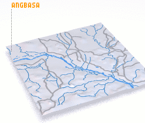 Places with similar names to Angbasa, Nigeria ::
// Ancabasse (GW)
Disclaimer :: Information on this page comes without warranty of any kind |
||
|
Where is Angbasa? Elevation and coordinates ::
Latitude (lat): 8°56'0"N Longitude (lon): 6°2'0"E
Elevation (approx.): 108m (map arrows pan, magnifying glasses zoom) |
||
|
Visiting Angbasa? Hotel/Accommodation ::
Book a hotel in Angbasa Travel Guide ::
Buy a travel guide for Nigeria rental cars ::
car rental offers GPS waypoint ::
download a GPX waypoint (PoI) of Angbasa for your GPS receiver
|
||