|
search place name
|
||
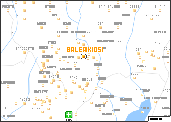
Bale Akiosi (Ogun, Nigeria)Bale Akiosi is a town in the Ogun region of Nigeria. An overview map of the region around Bale Akiosi is displayed below.
regional and 3d topo map of Bale Akiosi, Nigeria ::
Bale Akiosi airports ::
The nearest airport is LOS - Lagos Murtala Muhammed, located 12.3 km south of Bale Akiosi.
Other airports nearby include IBA - Ibadan (102.0 km north east), COO - Cotonou Cadjehoun (113.1 km west), AKR - Akure (224.0 km east), ILR - Ilorin (231.5 km north east), Nearby towns ::
Olori (0.7km north east) //
Onibudo (1.6km north east) //
Adiyan (1.7km north west) //
Otun (1.9km east) //
Lambe (2.5km north) //
Iju (2.5km south west) //
Akute-Oja (2.5km east) //
Isasi (3.2km south east) //
Atogun (3.7km north) //
Oke-Aro (3.8km west) //
Mawere (3.8km south east) //
Igaun (4.1km north east) //
Orudu (4.3km north) //
Iju Junction (4.3km south west) //
Isaga-Abosule (4.7km west) //
Omole (5.0km south) //
Ifako (5.2km south west) //
Coker (5.4km south west) //
Aguda (5.5km south) //
Legun (5.5km north) //
Oluwo Ibaragun (5.5km north) //
Alagbado (5.7km west) //
Ijaiye (5.8km south) //
Iseri (6.0km south east) //
Iseri-Oke (6.0km south east) //
George (6.2km south) //
Olowoira (6.5km south) //
Magboro-Akeran (6.5km north east) //
Oluwo (6.5km north west) //
[all distances 'as the bird flies' and approximate]  Places with similar names to Bale Akiosi, Nigeria ::
Disclaimer :: Information on this page comes without warranty of any kind |
||
|
Where is Bale Akiosi? Elevation and coordinates ::
Latitude (lat): 6°41'2"N Longitude (lon): 3°21'12"E
Elevation (approx.): 48m (map arrows pan, magnifying glasses zoom) |
||
|
Visiting Bale Akiosi? Hotel/Accommodation ::
Book a hotel in Bale Akiosi Travel Guide ::
Buy a travel guide for Nigeria rental cars ::
car rental offers GPS waypoint ::
download a GPX waypoint (PoI) of Bale Akiosi for your GPS receiver
|
||