|
search place name
|
||
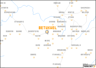
Betukwel (Gongola, Nigeria)Betukwel is a town in the Gongola region of Nigeria. An overview map of the region around Betukwel is displayed below.
regional and 3d topo map of Betukwel, Nigeria ::
Betukwel airports ::
The nearest airport is BPC - Bamenda, located 127.4 km south east of Betukwel.
Other airports nearby include MDI - Makurdi (134.1 km north west), ENU - Enugu (172.5 km west), BFX - Bafoussam (180.6 km south east), CBQ - Calabar (198.8 km south west), Nearby towns ::
Bebuachuan (1.8km east) //
Kakum (1.9km north) //
Ohong (2.6km south east) //
Ibong (3.7km south) //
Babubua (3.7km east) //
Bedia (4.1km south east) //
Ukambi (4.1km north east) //
Kutia (4.1km south west) //
Okorotong (5.5km west) //
Ukoshie (5.6km south) //
Bagiaba (5.8km east) //
Buahuan (5.8km east) //
Atekpe (6.7km north east) //
Buagbong (6.7km north east) //
Okpe (6.7km south west) //
Kakulaka (9.2km south east) //
Bagbikba (9.2km south east) //
Obudu (9.2km north east) //
[all distances 'as the bird flies' and approximate] 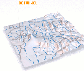 Places with similar names to Betukwel, Nigeria :: Disclaimer :: Information on this page comes without warranty of any kind |
||
|
Where is Betukwel? Elevation and coordinates ::
Latitude (lat): 6°36'0"N Longitude (lon): 9°7'0"E
Elevation (approx.): 202m (map arrows pan, magnifying glasses zoom) |
||
|
Visiting Betukwel? Hotel/Accommodation ::
Book a hotel in Betukwel Travel Guide ::
Buy a travel guide for Nigeria rental cars ::
car rental offers GPS waypoint ::
download a GPX waypoint (PoI) of Betukwel for your GPS receiver
|
||