|
search place name
|
||
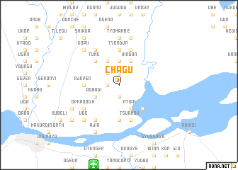
Chagu (Gongola, Nigeria)Chagu is a town in the Gongola region of Nigeria. An overview map of the region around Chagu is displayed below.
regional and 3d topo map of Chagu, Nigeria ::
Chagu airports ::
The nearest airport is MDI - Makurdi, located 13.1 km south of Chagu.
Other airports nearby include ENU - Enugu (191.0 km south west), ABV - Abuja Nnamdi Azikiwe Intl (201.6 km north west), JOS - Jos Yakubu Gowon (203.1 km north), BPC - Bamenda (255.2 km south east), Nearby towns ::
Ankegh (1.9km north) //
Aga (1.9km north) //
Tyo (1.9km south) //
Okoho (1.8km west) //
Dafa (1.9km south) //
Tyodugh (1.9km south) //
Marondu (1.9km south) //
Bende (2.6km north west) //
Atim (3.7km north) //
Beke (4.1km north west) //
Agber (4.1km north west) //
Hindan (4.1km north east) //
Opin (4.1km north west) //
Agbadi (4.1km south west) //
Akauer (4.1km south east) //
Gaval (4.1km south east) //
Nyiam (4.1km south east) //
Agena (5.2km north west) //
Tume (5.2km north west) //
Change (5.2km south east) //
Swam (5.6km south) //
Tyondun (5.6km north) //
Ajaver (5.5km west) //
Chongu (5.9km north) //
Tsuambu (5.9km south) //
Boigo (6.7km north west) //
Nyamkor (6.7km south west) //
Kwabo (6.6km south west) //
Orkpoogh (6.6km south west) //
[all distances 'as the bird flies' and approximate]  Places with similar names to Chagu, Nigeria ::
Disclaimer :: Information on this page comes without warranty of any kind |
||
|
Where is Chagu? Elevation and coordinates ::
Latitude (lat): 7°49'0"N Longitude (lon): 8°39'0"E
Elevation (approx.): 100m (map arrows pan, magnifying glasses zoom) |
||
|
Visiting Chagu? Hotel/Accommodation ::
Book a hotel in Chagu Travel Guide ::
Buy a travel guide for Nigeria rental cars ::
car rental offers GPS waypoint ::
download a GPX waypoint (PoI) of Chagu for your GPS receiver
|
||