|
search place name
|
||
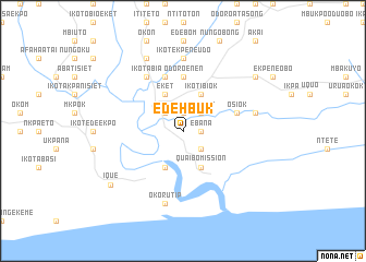
Edehbuk (Gongola, Nigeria)Edehbuk is a town in the Gongola region of Nigeria. An overview map of the region around Edehbuk is displayed below.
regional and 3d topo map of Edehbuk, Nigeria ::
Edehbuk airports ::
The nearest airport is CBQ - Calabar, located 59.3 km north east of Edehbuk.
Other airports nearby include PHC - Port Hartcourt Port Harcourt Intl (119.4 km west), SSG - Malabo (127.2 km south east), TKC - Tiko (167.1 km east), DLA - Douala (207.7 km east), Nearby towns ::
Afaha Uqua (1.9km north) //
Ede Urua (1.9km north) //
Ebana (1.8km east) //
Afaha Atai (2.6km north east) //
Afaha Eket (2.6km north west) //
Iko Eket (2.6km north east) //
Esit Urua (2.6km south east) //
Eket (4.1km north west) //
Ikot Ibiok (4.1km north east) //
Nditia (4.1km south west) //
Qua Ibo Mission (4.1km south east) //
Efriyo (5.6km north) //
Ikot Udoma (5.6km north) //
Odoro Enen (5.6km north) //
Osiok (5.8km east) //
Idua (5.9km north) //
Afia Nsit (5.9km north) //
Ikot Abia (6.7km north west) //
Ikot Nsidibe (6.7km north west) //
Ikot Ekpene Udo (7.4km north) //
Edor (7.6km east) //
Okorutip (7.6km south) //
Ikot Abasi (8.3km north west) //
Ique (9.2km south west) //
Efoi (9.2km north east) //
[all distances 'as the bird flies' and approximate] 
Disclaimer :: Information on this page comes without warranty of any kind |
||
|
Where is Edehbuk? Elevation and coordinates ::
Latitude (lat): 4°37'0"N Longitude (lon): 7°57'0"E
Elevation (approx.): 15m (map arrows pan, magnifying glasses zoom) |
||
|
Visiting Edehbuk? Hotel/Accommodation ::
Book a hotel in Edehbuk Travel Guide ::
Buy a travel guide for Nigeria rental cars ::
car rental offers GPS waypoint ::
download a GPX waypoint (PoI) of Edehbuk for your GPS receiver
|
||