|
search place name
|
||
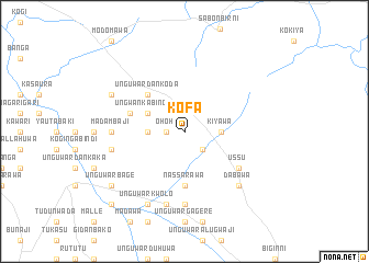
Kofa (Gongola, Nigeria)Kofa is a town in the Gongola region of Nigeria. An overview map of the region around Kofa is displayed below.
regional and 3d topo map of Kofa, Nigeria ::
Kofa airports ::
The nearest airport is QUS - Gusau, located 32.2 km south of Kofa.
Other airports nearby include MFG - Maradi (122.3 km north), ZAR - Zaria (176.0 km south east), SKO - Sokoto Sadiq Abubakar Iii Intl (178.8 km west), KAN - Kano Mallam Aminu Intl (194.6 km east), Nearby towns ::
Ohoh (1.8km west) //
Unguwar Makera (2.6km south east) //
Ilojia (3.6km west) //
Kiyawa (3.6km east) //
Ungwan Kabin Giro (4.1km north west) //
Unguwar Dan Koda (5.2km north west) //
Nassarawa (5.6km south) //
Gworah (5.7km west) //
Ussu (6.6km south east) //
Madambaji (7.2km west) //
Unguwar Farin Mallam (7.4km south) //
Kanu (7.5km west) //
Balitawa (7.6km south) //
Dabawa (7.8km south east) //
Kirifada (8.1km north west) //
Unguwar Kwolo (8.2km south west) //
Unguwar Bage (9.1km south west) //
Ruwan Kura (10.4km south west) //
[all distances 'as the bird flies' and approximate] 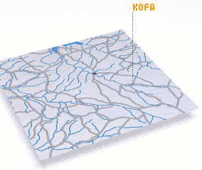 Places with similar names to Kofa, Nigeria ::
Disclaimer :: Information on this page comes without warranty of any kind |
||
|
Where is Kofa? Elevation and coordinates ::
Latitude (lat): 12°27'0"N Longitude (lon): 6°47'0"E
Elevation (approx.): 440m (map arrows pan, magnifying glasses zoom) |
||
|
Visiting Kofa? Hotel/Accommodation ::
Book a hotel in Kofa Travel Guide ::
Buy a travel guide for Nigeria rental cars ::
car rental offers GPS waypoint ::
download a GPX waypoint (PoI) of Kofa for your GPS receiver
|
||