|
search place name
|
||
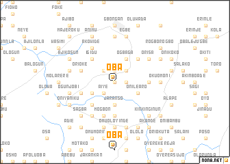
Oba (Gongola, Nigeria)Oba is a town in the Gongola region of Nigeria. An overview map of the region around Oba is displayed below.
regional and 3d topo map of Oba, Nigeria ::
Oba airports ::
The nearest airport is IBA - Ibadan, located 41.1 km west of Oba.
Other airports nearby include AKR - Akure (106.1 km east), ILR - Ilorin (118.0 km north), LOS - Lagos Murtala Muhammed (144.5 km south west), BNI - Benin (181.6 km south east), Nearby towns ::
Olukunle (0.0km north) //
Onikan (1.8km east) //
Bembe (1.9km north) //
Aiye (2.6km south west) //
Jagun (2.6km north west) //
Ajo (2.6km north west) //
Balogun (2.6km north east) //
Jaranso (3.7km south) //
Eiye Olupele (4.1km south west) //
Onilearo (4.1km south east) //
Ogbaga (4.1km north east) //
Olokoko (5.2km south west) //
Igidu (5.2km north west) //
Eiyentale (5.2km north east) //
Eleiye Oke (5.6km south) //
Ogundijo (5.5km east) //
Eiye Alada (5.8km west) //
Budojoko (5.8km west) //
Babalola (5.8km west) //
Ori Oke (5.8km west) //
Mogbon (5.9km south) //
Bamidele (5.9km south) //
Akowide (6.7km north west) //
Base (6.7km south west) //
Orisa (6.6km north east) //
Omu Alajo (7.4km south) //
Omu Oloyinde (7.4km south) //
Akiriboto Elede (7.4km north) //
Jatina (7.4km east) //
[all distances 'as the bird flies' and approximate]  Places with similar names to Oba, Nigeria ::
Disclaimer :: Information on this page comes without warranty of any kind |
||
|
Where is Oba? Elevation and coordinates ::
Latitude (lat): 7°23'0"N Longitude (lon): 4°21'0"E
Elevation (approx.): 209m (map arrows pan, magnifying glasses zoom) |
||
|
Visiting Oba? Hotel/Accommodation ::
Book a hotel in Oba Travel Guide ::
Buy a travel guide for Nigeria rental cars ::
car rental offers GPS waypoint ::
download a GPX waypoint (PoI) of Oba for your GPS receiver
|
||