|
search place name
|
||
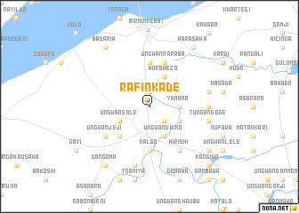
Rafin Kade (Gongola, Nigeria)Rafin Kade is a town in the Gongola region of Nigeria. An overview map of the region around Rafin Kade is displayed below.
regional and 3d topo map of Rafin Kade, Nigeria ::
Rafin Kade airports ::
The nearest airport is SKO - Sokoto Sadiq Abubakar Iii Intl, located 125.2 km north east of Rafin Kade.
Nearby towns ::
Goru (1.9km north) //
Ungwan Lona (1.9km north) //
Marafaka (2.6km south east) //
Yamama (3.6km east) //
Jambaki (4.1km south east) //
Ungwan Sale (4.1km south west) //
Wurohezo (4.1km north east) //
Ungwan Dikko (4.1km south east) //
Ungwan Ardua (5.2km south west) //
Kalgo (5.6km south) //
Bulassa (5.6km north) //
Ungwan Naraba (5.8km north) //
Hirishi (6.6km south east) //
Ungwan Jeji (6.6km south west) //
Ungwan Merogo (7.2km east) //
Sodangi (7.5km east) //
Badaria Baba (7.6km south) //
Tungan Goge (7.5km east) //
Badaria (9.2km north west) //
Harasawa (9.2km north east) //
Dangoma (9.2km south west) //
Basaura (9.1km south east) //
Kangiwa (10.4km south east) //
[all distances 'as the bird flies' and approximate] 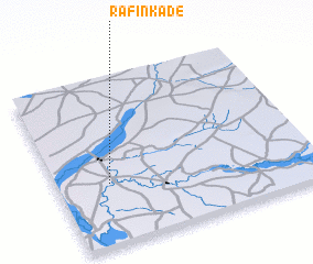 Places with similar names to Rafin Kade, Nigeria ::
// Rafin Kada (NG)
Disclaimer :: Information on this page comes without warranty of any kind |
||
|
Where is Rafin Kade? Elevation and coordinates ::
Latitude (lat): 12°22'0"N Longitude (lon): 4°12'0"E
Elevation (approx.): 222m (map arrows pan, magnifying glasses zoom) |
||
|
Visiting Rafin Kade? Hotel/Accommodation ::
Book a hotel in Rafin Kade Travel Guide ::
Buy a travel guide for Nigeria rental cars ::
car rental offers GPS waypoint ::
download a GPX waypoint (PoI) of Rafin Kade for your GPS receiver
|
||