|
search place name
|
||
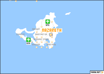
Nazareth (Netherlands Antilles)Nazareth is a town in Netherlands Antilles. An overview map of the region around Nazareth is displayed below.
regional and 3d topo map of Nazareth, Netherlands Antilles ::
Nazareth airports ::
The nearest airport is SFG - St. Martin Grand Case, located 5.7 km north of Nazareth.
Other airports nearby include SXM - Philipsburg Princess Juliana Intl (8.1 km west), AXA - The Valley Wallblake (17.3 km north), EUX - Oranjestad F D Roosevelt (61.5 km south), SKB - Basse Terre Robert L Bradshaw (88.3 km south), Nearby towns ::
Belvédère (0.0km north) //
Union Farm (0.0km north) //
One Hoe (0.0km north) //
Quartier dʼOrléans (1.9km north) //
Lower Prince's Quarter (1.9km south) //
Upper Prince's Quarter (1.9km south) //
Sucker Garden (1.9km south) //
Spring Garden (1.9km south) //
Pine Garden (1.9km south) //
Defiance (1.9km south) //
Middle Region (1.9km south) //
Colombier (2.6km north west) //
Trial (2.6km south west) //
Mary's Fancy (2.6km south west) //
Over the Pond (2.6km south west) //
Rockland (2.6km south west) //
Saunders (2.6km south west) //
Philipsburg (3.7km south) //
Experiment (3.7km south) //
Bloomingdale (3.7km south) //
The Hope (3.7km south) //
Vineyard (3.7km south) //
Saint Peter (3.5km west) //
The Villa (4.1km south west) //
Hameau du Pont (4.0km north west) //
Cul de Sac (4.0km south west) //
Prospect Farm (4.0km south west) //
Industrie (4.0km south west) //
Koolbaai (4.0km south west) //
[all distances 'as the bird flies' and approximate]  Places with similar names to Nazareth, Netherlands Antilles ::
Disclaimer :: Information on this page comes without warranty of any kind |
||
|
Where is Nazareth? Elevation and coordinates ::
Latitude (lat): 18°3'0"N Longitude (lon): 63°2'0"W
Elevation (approx.): 54m (map arrows pan, magnifying glasses zoom) |
||
|
Visiting Nazareth? Hotel/Accommodation ::
Book a hotel in Nazareth Travel Guide ::
rental cars ::
car rental offers GPS waypoint ::
download a GPX waypoint (PoI) of Nazareth for your GPS receiver
|
||