|
search place name
|
||
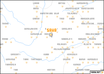
Sawa (Gongola, Nigeria)Sawa is a town in the Gongola region of Nigeria. An overview map of the region around Sawa is displayed below.
regional and 3d topo map of Sawa, Nigeria ::
Sawa airports ::
The nearest airport is YOL - Yola, located 87.4 km north east of Sawa.
Other airports nearby include GOU - Garoua (179.6 km north east), NGE - N'gaoundere Ngaoundere (238.5 km south east), Nearby towns ::
Moki (1.8km west) //
Sebore Bata (1.9km north) //
Boyu (2.6km north east) //
Gangmaaji (3.7km south) //
Jauro Buba (4.1km north west) //
Pola Kuni (5.2km south east) //
Gungu Saje (5.5km west) //
Jauro Haman (5.6km south) //
Gangpana (5.5km west) //
Ganglare (5.8km east) //
Gangfada (5.8km east) //
Sabon Layi (5.8km east) //
Pola Jauro Baba (6.7km south east) //
Gangzonen (6.6km south east) //
Taso (6.7km north east) //
Binyeri (6.7km north west) //
Gangwere (7.3km west) //
Gashifa (7.6km east) //
Deja (7.6km north) //
Alahoke (7.6km south) //
Dendi Jawere (7.6km west) //
Kubbi (7.6km south) //
Wuro Yakubu (7.6km north) //
Gabisa (7.8km north west) //
Gangtari (8.2km south east) //
Kotulo (9.2km south east) //
Kibon (9.2km north east) //
Gangjubi (9.2km south east) //
Kavani (9.2km south east) //
[all distances 'as the bird flies' and approximate]  Places with similar names to Sawa, Nigeria ::
Disclaimer :: Information on this page comes without warranty of any kind |
||
|
Where is Sawa? Elevation and coordinates ::
Latitude (lat): 8°42'0"N Longitude (lon): 11°52'0"E
Elevation (approx.): 546m (map arrows pan, magnifying glasses zoom) |
||
|
Visiting Sawa? Hotel/Accommodation ::
Book a hotel in Sawa Travel Guide ::
Buy a travel guide for Nigeria rental cars ::
car rental offers GPS waypoint ::
download a GPX waypoint (PoI) of Sawa for your GPS receiver
|
||