|
search place name
|
||
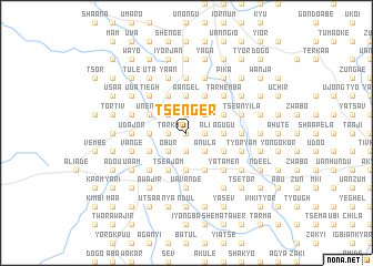
Tsenger (Gongola, Nigeria)Tsenger is a town in the Gongola region of Nigeria. An overview map of the region around Tsenger is displayed below.
regional and 3d topo map of Tsenger, Nigeria ::
Tsenger airports ::
The nearest airport is MDI - Makurdi, located 41.1 km north of Tsenger.
Other airports nearby include ENU - Enugu (147.5 km south west), BPC - Bamenda (222.4 km south east), ABV - Abuja Nnamdi Azikiwe Intl (235.4 km north west), BFX - Bafoussam (279.0 km south east), Nearby towns ::
Kyayel (0.0km north) //
Kunde (0.0km north) //
Gbangi (0.0km north) //
Heghel (0.0km north) //
Nongo (0.0km north) //
Azaho (0.0km north) //
Jiga (0.0km north) //
Tarka (1.8km west) //
Gbem (1.8km west) //
Ayange (1.8km west) //
Agbatso (1.8km west) //
Gege (1.9km south) //
Agrigbe (1.9km south) //
Abunde (1.9km south) //
Tume (1.9km south) //
Tahembe (1.8km east) //
Ali (1.8km east) //
Agbalagba (1.8km east) //
Beaku (1.8km east) //
Tema (1.8km east) //
Iorsue (1.8km east) //
Nyam (1.9km north) //
Toho (1.9km north) //
Amkov (2.6km south west) //
Torugh (2.6km south west) //
Obur (2.6km south west) //
Tyorkpa (2.6km north west) //
Ashwe (2.6km north west) //
Aondo (2.6km north west) //
[all distances 'as the bird flies' and approximate] 
Disclaimer :: Information on this page comes without warranty of any kind |
||
|
Where is Tsenger? Elevation and coordinates ::
Latitude (lat): 7°20'0"N Longitude (lon): 8°35'0"E
Elevation (approx.): 158m (map arrows pan, magnifying glasses zoom) |
||
|
Visiting Tsenger? Hotel/Accommodation ::
Book a hotel in Tsenger Travel Guide ::
Buy a travel guide for Nigeria rental cars ::
car rental offers GPS waypoint ::
download a GPX waypoint (PoI) of Tsenger for your GPS receiver
|
||