|
search place name
|
||
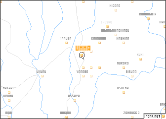
Umma (Gongola, Nigeria)Umma is a town in the Gongola region of Nigeria. An overview map of the region around Umma is displayed below.
regional and 3d topo map of Umma, Nigeria ::
Umma airports ::
The nearest airport is MXJ - Minna New, located 93.4 km south east of Umma.
Other airports nearby include KAD - Kaduna (141.0 km east), ZAR - Zaria (194.6 km north east), ABV - Abuja Nnamdi Azikiwe Intl (202.4 km south east), QUS - Gusau (207.7 km north), Nearby towns ::
Kagari (1.9km north) //
Bejagira (1.9km north) //
Shiuba (1.9km south) //
Taberima (2.6km north east) //
Gidan Sarikin Wuchanja (2.6km south east) //
Aikira Bitari (3.7km south) //
Yaraba (3.7km south) //
Uregi (4.1km south east) //
Gidan Tukunguna (4.1km south east) //
Kairumba (5.2km north east) //
Maruba (5.2km north west) //
Gidan Damao Imagu (9.2km north east) //
Ekushe (9.2km north east) //
[all distances 'as the bird flies' and approximate] 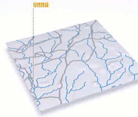 Places with similar names to Umma, Nigeria ::
Disclaimer :: Information on this page comes without warranty of any kind |
||
|
Where is Umma? Elevation and coordinates ::
Latitude (lat): 10°24'0"N Longitude (lon): 6°4'0"E
Elevation (approx.): 410m (map arrows pan, magnifying glasses zoom) |
||
|
Visiting Umma? Hotel/Accommodation ::
Book a hotel in Umma Travel Guide ::
Buy a travel guide for Nigeria rental cars ::
car rental offers GPS waypoint ::
download a GPX waypoint (PoI) of Umma for your GPS receiver
|
||