|
search place name
|
||
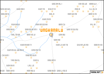
Ungwan Alu (Gongola, Nigeria)Ungwan Alu is a town in the Gongola region of Nigeria. An overview map of the region around Ungwan Alu is displayed below.
regional and 3d topo map of Ungwan Alu, Nigeria ::
Ungwan Alu airports ::
The nearest airport is SKO - Sokoto Sadiq Abubakar Iii Intl, located 65.7 km north east of Ungwan Alu.
Other airports nearby include QUS - Gusau (205.0 km east), Nearby towns ::
Rugar Shaudu (2.6km north west) //
Samma (2.6km south east) //
Gambu (3.6km east) //
Dogondaji (4.1km north west) //
Namangoma (5.2km north west) //
Jariagi (5.2km north west) //
Kwalkwato (5.2km south east) //
Ungwan Kambari (5.2km south east) //
Bancu (5.2km north east) //
Kwazari (5.8km north) //
Barkeji (7.2km west) //
Sala (7.4km north) //
Sabon Birni (7.5km west) //
Daringuru (7.5km east) //
Kporaye (7.8km south west) //
Maruda (8.1km north west) //
Nabaguda (10.4km south west) //
Mandera (10.4km north east) //
[all distances 'as the bird flies' and approximate] 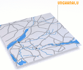 Places with similar names to Ungwan Alu, Nigeria ::
// Ungwan Alu (NG)
Disclaimer :: Information on this page comes without warranty of any kind |
||
|
Where is Ungwan Alu? Elevation and coordinates ::
Latitude (lat): 12°27'0"N Longitude (lon): 4°50'0"E
Elevation (approx.): 261m (map arrows pan, magnifying glasses zoom) |
||
|
Visiting Ungwan Alu? Hotel/Accommodation ::
Book a hotel in Ungwan Alu Travel Guide ::
Buy a travel guide for Nigeria rental cars ::
car rental offers GPS waypoint ::
download a GPX waypoint (PoI) of Ungwan Alu for your GPS receiver
|
||